|
|
|
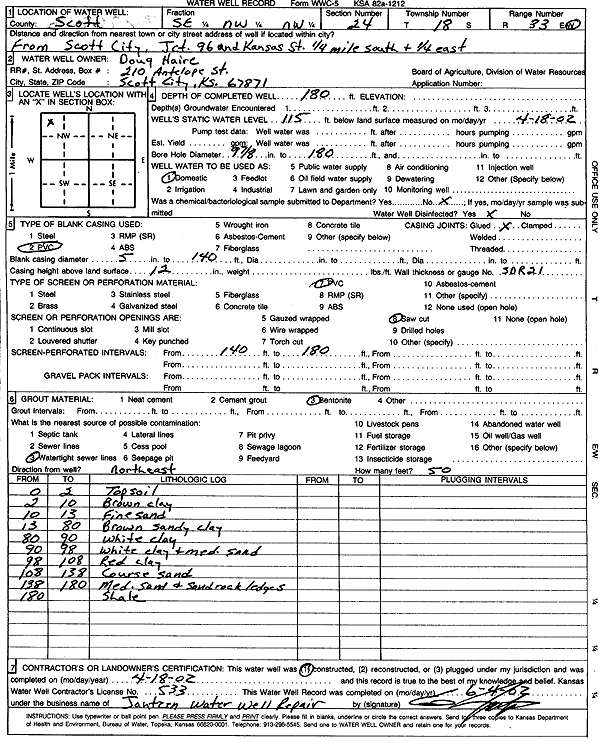
Specific Water Well Detail |
|
|
| Location Info | |||
| Owner: Haire, Doug | Status: Constructed | ||
| Location: T18S, R33W, Sec. 24, SE NW NW | County: Scott | ||
| Directions: from Jct 96 and Kansas St, Scott City: .25 mi S, .25 mi E | |||
| Latitude: 38.4796324 | Longitude: -100.9215667 | Datum NAD 27 | |
| Latitude: 38.4796518 | Longitude: -100.9219953 | Datum NAD 83 | |
| Longitude and latitude calculated by Survey from township-range-section-quarter calls. Only good to within the quarter call accuracy. | |||
| View well on interactive map | |||
| General Info | ||
| Well Depth: 180 ft. | Elevation: ft. | |
| Static Water Level: 115 ft. | Est. Yield: gpm. | |
| Comp. Date: 18-Apr-2002 | Well Use: Domestic | |
| DWR Applic. #: | Other ID: | |
| Driller Info | ||
| Driller: Jantzen Water Well Reair | License #: 533 | |
| Scanned Form | View scan |
|
Chemical Sample Submitted?:
Water Well disinfected?: | ||
| Casing Info | ||
| Casing Type:
Casing Joints: |
Diam: in. to ft | |
| Casing height above land surface: in
Casing Weight: lbs/ft Wall thickness or gauge no.: | ||
| Screen and Perforation Info | ||
| Screen Type: | Screen Openings: | |
| Screen-perforated intervals | From: ft to ft | |
| Gravel pack intervals | From: ft to ft | |
| Grout Info | ||
| Grout used: | From: to ft | |
| Source of Possible Contamination | ||
| Source: | ||
| Direction from well: | Distance: ft | |
| Lithologic Log
(Log data entered by KGS.) | ||
| From: 0 ft. to 2 ft. | Top soil | |
| From: 2 ft. to 10 ft. | Brown clay | |
| From: 10 ft. to 13 ft. | Fine sand | |
| From: 13 ft. to 80 ft. | Brown sandy clay | |
| From: 80 ft. to 90 ft. | White clay | |
| From: 90 ft. to 98 ft. | White clay and medium sand | |
| From: 98 ft. to 108 ft. | Red clay | |
| From: 108 ft. to 138 ft. | Coarse sand | |
| From: 138 ft. to 180 ft. | Medium sand and sand rock ledges | |
| From: 180 ft. to ft. | Shale | |