|
|
|
Specific Water Well Detail |
|
|
| Location Info | |||
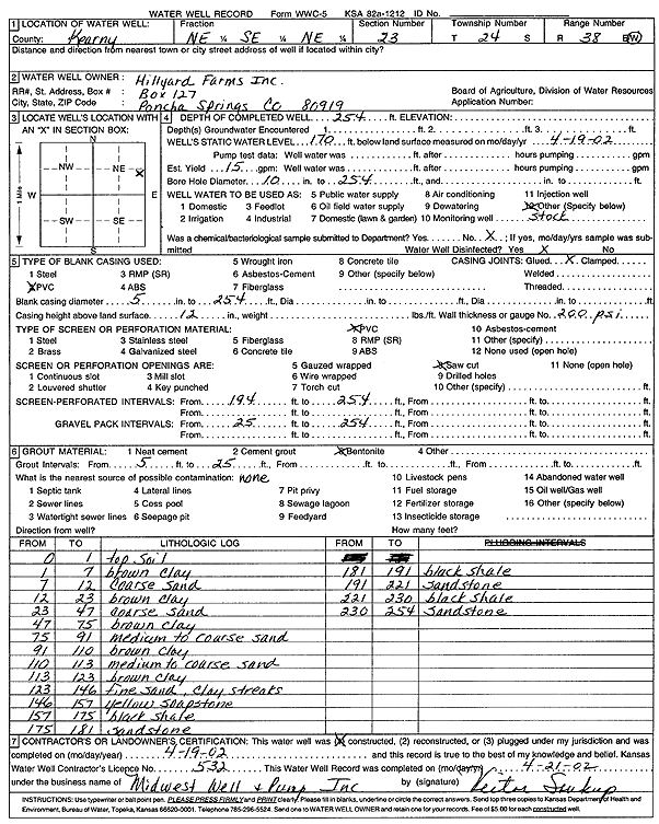
| Owner: Hillyard Farms, Inc. | Status: Constructed | ||
| Location: T24S, R38W, Sec. 23, NE SE NE | County: Kearny | ||
| Directions: | |||
| Latitude: 37.9541291 | Longitude: -101.4508383 | Datum NAD 27 | |
| Latitude: 37.9541455 | Longitude: -101.451286 | Datum NAD 83 | |
| Longitude and latitude calculated by Survey from township-range-section-quarter calls. Only good to within the quarter call accuracy. | |||
| View well on interactive map | |||
| General Info | ||
| Well Depth: 254 ft. | Elevation: ft. | |
| Static Water Level: 170 ft. | Est. Yield: 15 gpm. | |
| Comp. Date: 19-Apr-2002 | Well Use: Domestic, Livestock | |
| DWR Applic. #: | Other ID: | |
| Driller Info | ||
| Driller: Midwest Well & Pump, Inc. | License #: 532 | |
| Scanned Form | View scan |
|
Chemical Sample Submitted?:
Water Well disinfected?: | ||
| Casing Info | ||
| Casing Type:
Casing Joints: |
Diam: in. to ft | |
| Casing height above land surface: in
Casing Weight: lbs/ft Wall thickness or gauge no.: | ||
| Screen and Perforation Info | ||
| Screen Type: | Screen Openings: | |
| Screen-perforated intervals | From: ft to ft | |
| Gravel pack intervals | From: ft to ft | |
| Grout Info | ||
| Grout used: | From: to ft | |
| Source of Possible Contamination | ||
| Source: | ||
| Direction from well: | Distance: ft | |
| Lithologic Log
(Log data entered by KGS.) | ||
| From: 0 ft. to 1 ft. | top soil | |
| From: 1 ft. to 7 ft. | brown clay | |
| From: 7 ft. to 12 ft. | coarse sand | |
| From: 12 ft. to 23 ft. | brown clay | |
| From: 23 ft. to 47 ft. | coarse sand | |
| From: 47 ft. to 75 ft. | brown clay | |
| From: 75 ft. to 91 ft. | medium to coarse sand | |
| From: 91 ft. to 110 ft. | brown clay | |
| From: 110 ft. to 113 ft. | medium to coarse sand | |
| From: 113 ft. to 123 ft. | brown clay | |
| From: 123 ft. to 146 ft. | fine sand, clay streaks | |
| From: 146 ft. to 157 ft. | yellow soapstone | |
| From: 157 ft. to 175 ft. | black shale | |
| From: 175 ft. to 181 ft. | sandstone | |
| From: 181 ft. to 191 ft. | black shale | |
| From: 191 ft. to 221 ft. | sandstone | |
| From: 221 ft. to 230 ft. | black shale | |
| From: 230 ft. to 254 ft. | sandstone | |