|
|
|
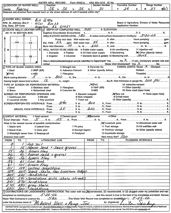
Specific Water Well Detail |
|
|
| Location Info | |||
| Owner: Hittle, Bill | Status: Constructed | ||
| Location: T24S, R37W, Sec. 31, SE SE SE | County: Kearny | ||
| Directions: | |||
| Latitude: 37.9161155 | Longitude: -101.4144152 | Datum NAD 27 | |
| Latitude: 37.9161324 | Longitude: -101.4148632 | Datum NAD 83 | |
| Longitude and latitude calculated by Survey from township-range-section-quarter calls. Only good to within the quarter call accuracy. | |||
| View well on interactive map | |||
| General Info | ||
| Well Depth: 300 ft. | Elevation: ft. | |
| Static Water Level: 180 ft. | Est. Yield: 22 gpm. | |
| Comp. Date: 20-May-2002 | Well Use: Domestic, Livestock | |
| DWR Applic. #: | Other ID: | |
| Driller Info | ||
| Driller: Midwest Well & Pump, Inc. | License #: 532 | |
| Scanned Form | View scan |
|
Chemical Sample Submitted?:
Water Well disinfected?: | ||
| Casing Info | ||
| Casing Type:
Casing Joints: |
Diam: in. to ft | |
| Casing height above land surface: in
Casing Weight: lbs/ft Wall thickness or gauge no.: | ||
| Screen and Perforation Info | ||
| Screen Type: | Screen Openings: | |
| Screen-perforated intervals | From: ft to ft | |
| Gravel pack intervals | From: ft to ft | |
| Grout Info | ||
| Grout used: | From: to ft | |
| Source of Possible Contamination | ||
| Source: | ||
| Direction from well: | Distance: ft | |
| Lithologic Log
(Log data entered by KGS.) | ||
| From: 0 ft. to 1 ft. | top soil | |
| From: 1 ft. to 15 ft. | coarse sand and small gravel | |
| From: 15 ft. to 26 ft. | brown clay | |
| From: 26 ft. to 40 ft. | coarse sand and gravel | |
| From: 40 ft. to 56 ft. | brown clay | |
| From: 56 ft. to 61 ft. | fine sand | |
| From: 61 ft. to 101 ft. | brown clay | |
| From: 101 ft. to 109 ft. | yellow soapstone | |
| From: 109 ft. to 205 ft. | black shale, few limestone ledges | |
| From: 205 ft. to 230 ft. | sandstone | |
| From: 230 ft. to 241 ft. | sandstone with shale streaks | |
| From: 241 ft. to 270 ft. | sandstone | |
| From: 270 ft. to 280 ft. | gray shale | |
| From: 280 ft. to 300 ft. | sandstone | |