|
|
|
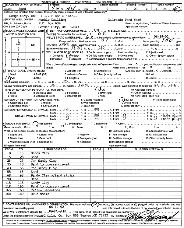
Specific Water Well Detail |
|
|
| Location Info | |||
| Owner: Henkle Drilling - Wilroads Feed Yard | Status: Constructed | ||
| Location: T27S, R24W, Sec. 9, SW NW NW | County: Ford | ||
| Directions: from Dodge City: 1.5 mi E, N into site | |||
| Latitude: 37.718649 | Longitude: -99.959199 | Datum NAD 27 | |
| Latitude: 37.7186694 | Longitude: -99.9596096 | Datum NAD 83 | |
| Longitude and latitude calculated by Survey from township-range-section-quarter calls. Only good to within the quarter call accuracy. | |||
| View well on interactive map | |||
| General Info | ||
| Well Depth: 180 ft. | Elevation: ft. | |
| Static Water Level: 68 ft. | Est. Yield: 100 gpm. | |
| Comp. Date: 19-Jun-2002 | Well Use: Feedlot | |
| DWR Applic. #: | Other ID: | |
| Driller Info | ||
| Driller: Howard Drilling Company AG, LLC | License #: 430 | |
| Scanned Form | View scan |
|
Chemical Sample Submitted?:
Water Well disinfected?: | ||
| Casing Info | ||
| Casing Type:
Casing Joints: |
Diam: in. to ft | |
| Casing height above land surface: in
Casing Weight: lbs/ft Wall thickness or gauge no.: | ||
| Screen and Perforation Info | ||
| Screen Type: | Screen Openings: | |
| Screen-perforated intervals | From: ft to ft | |
| Gravel pack intervals | From: ft to ft | |
| Grout Info | ||
| Grout used: | From: to ft | |
| Source of Possible Contamination | ||
| Source: | ||
| Direction from well: | Distance: ft | |
| Lithologic Log
(Log data entered by KGS.) | ||
| From: 0 ft. to 15 ft. | sandy clay | |
| From: 15 ft. to 28 ft. | sand | |
| From: 28 ft. to 35 ft. | tan sandy clay | |
| From: 35 ft. to 43 ft. | sand to coarse gravel | |
| From: 43 ft. to 55 ft. | tan sandy clay | |
| From: 55 ft. to 68 ft. | sand | |
| From: 68 ft. to 98 ft. | sandy clay with sand strips | |
| From: 98 ft. to 115 ft. | sand | |
| From: 115 ft. to 118 ft. | sandy clay | |
| From: 118 ft. to 165 ft. | sand to coarse gravel | |
| From: 165 ft. to 168 ft. | yellow sandstone | |
| From: 168 ft. to 180 ft. | blue shale | |