|
|
|
Specific Water Well Detail |
|
|
| Location Info | |||
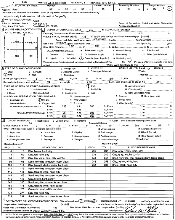
| Owner: Aquilla | Status: Constructed | ||
| Location: T26S, R25W, Sec. 16, SE SE NE | County: Ford | ||
| Directions: from Dodge City: 1 mi W, .5 mi N | |||
| Latitude: 37.7884027 | Longitude: -100.0522094 | Datum NAD 27 | |
| Latitude: 37.788423 | Longitude: -100.0526225 | Datum NAD 83 | |
| Longitude and latitude calculated by Survey from township-range-section-quarter calls. Only good to within the quarter call accuracy. | |||
| View well on interactive map | |||
| General Info | ||
| Well Depth: 250 ft. | Elevation: ft. | |
| Static Water Level: 138 ft. | Est. Yield: gpm. | |
| Comp. Date: 18-Jun-2002 | Well Use: Domestic, Lawn and Garden | |
| DWR Applic. #: | Other ID: | |
| Driller Info | ||
| Driller: Clarke Well and Equipment, Inc. | License #: 185 | |
| Scanned Form | View scan |
|
Chemical Sample Submitted?:
Water Well disinfected?: | ||
| Casing Info | ||
| Casing Type:
Casing Joints: |
Diam: in. to ft | |
| Casing height above land surface: in
Casing Weight: lbs/ft Wall thickness or gauge no.: | ||
| Screen and Perforation Info | ||
| Screen Type: | Screen Openings: | |
| Screen-perforated intervals | From: ft to ft | |
| Gravel pack intervals | From: ft to ft | |
| Grout Info | ||
| Grout used: | From: to ft | |
| Source of Possible Contamination | ||
| Source: | ||
| Direction from well: | Distance: ft | |
| Lithologic Log
(Log data entered by KGS.) | ||
| From: 0 ft. to 15 ft. | clay, brown, hard, silty | |
| From: 15 ft. to 60 ft. | clay, tan, hard, silty | |
| From: 60 ft. to 96 ft. | clay, tan, white, hard, silty, caliche | |
| From: 96 ft. to 105 ft. | sand, very fine to coarse, loose, clean | |
| From: 105 ft. to 111 ft. | clay, tan with black streaks, hard, silty | |
| From: 111 ft. to 115 ft. | sand, very fine to coarse, loose, clean | |
| From: 115 ft. to 143 ft. | clay, tan and white, hard, silty | |
| From: 143 ft. to 146 ft. | sand, very fine to coarse, loose, clean | |
| From: 146 ft. to 148 ft. | clay, brown, hard, sandy | |
| From: 148 ft. to 150 ft. | sand, very fine, coarse, loose, clean | |
| From: 150 ft. to 176 ft. | clay, tan and white, hard, sandy | |
| From: 176 ft. to 178 ft. | cemented sand, white, very hard | |
| From: 178 ft. to 223 ft. | clay, tan, hard, silty | |
| From: 223 ft. to 231 ft. | sand, very fine to coarse, loose, clean | |
| From: 231 ft. to 238 ft. | clay, gray, yellow, hard, silty | |
| From: 238 ft. to 240 ft. | clay, gray, red, hard, silty | |
| From: 240 ft. to 246 ft. | sand, very fine, fine, some medium, loose, clean | |
| From: 246 ft. to 253 ft. | clay, yellow, white, hard | |
| From: 253 ft. to 260 ft. | shale, black, hard, silty | |