|
|
|
Specific Water Well Detail |
|
|
| Location Info | |||
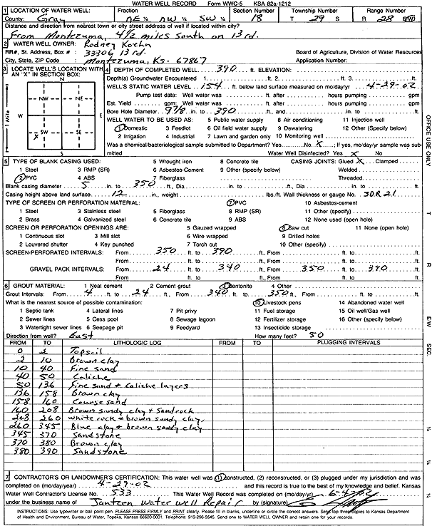
| Owner: Koehn, Rodney | Status: Constructed | ||
| Location: T29S, R28W, Sec. 18, NE NW SW | County: Gray | ||
| Directions: from Montezuma: 4.5 mi S on 13 Rd | |||
| Latitude: 37.5247829 | Longitude: -100.4299091 | Datum NAD 27 | |
| Latitude: 37.5248062 | Longitude: -100.4303358 | Datum NAD 83 | |
| Longitude and latitude calculated by Survey from township-range-section-quarter calls. Only good to within the quarter call accuracy. | |||
| View well on interactive map | |||
| General Info | ||
| Well Depth: 390 ft. | Elevation: ft. | |
| Static Water Level: 154 ft. | Est. Yield: gpm. | |
| Comp. Date: 29-Apr-2002 | Well Use: Domestic | |
| DWR Applic. #: | Other ID: | |
| Driller Info | ||
| Driller: Ed Jantzen Water Well Repair | License #: 533 | |
| Scanned Form | View scan |
|
Chemical Sample Submitted?:
Water Well disinfected?: | ||
| Casing Info | ||
| Casing Type:
Casing Joints: |
Diam: in. to ft | |
| Casing height above land surface: in
Casing Weight: lbs/ft Wall thickness or gauge no.: | ||
| Screen and Perforation Info | ||
| Screen Type: | Screen Openings: | |
| Screen-perforated intervals | From: ft to ft | |
| Gravel pack intervals | From: ft to ft | |
| Grout Info | ||
| Grout used: | From: to ft | |
| Source of Possible Contamination | ||
| Source: | ||
| Direction from well: | Distance: ft | |
| Lithologic Log
(Log data entered by KGS.) | ||
| From: 0 ft. to 2 ft. | Topsoil | |
| From: 2 ft. to 10 ft. | Brown clay | |
| From: 10 ft. to 40 ft. | Fine sand | |
| From: 40 ft. to 50 ft. | Caliche | |
| From: 50 ft. to 136 ft. | Fine sand and caliche layers | |
| From: 136 ft. to 158 ft. | Brown clay | |
| From: 158 ft. to 160 ft. | Coarse sand | |
| From: 160 ft. to 208 ft. | Brown sandy clay and sandrock | |
| From: 208 ft. to 260 ft. | White rock and brown sandy clay | |
| From: 260 ft. to 345 ft. | Blue clay and brown sandy clay | |
| From: 345 ft. to 370 ft. | Sandstone | |
| From: 370 ft. to 380 ft. | Brown clay | |
| From: 380 ft. to 390 ft. | Sandstone | |