|
|
|
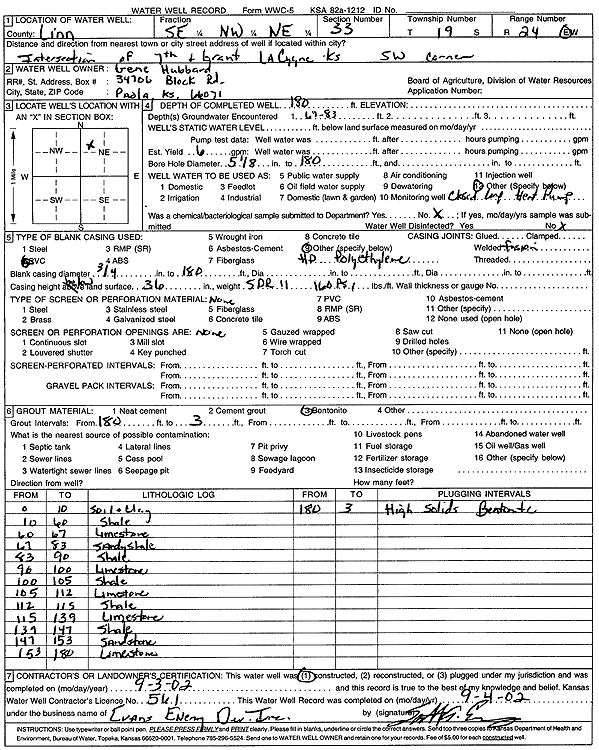
Specific Water Well Detail |
|
|
| Location Info | |||
| Owner: Hubbard, Gene | Status: Constructed | ||
| Location: T19S, R24E, Sec. 33, SE NW NE | County: Linn | ||
| Directions: SW corner of 7th and Grant, LaCygne | |||
| Latitude: 38.3571863 | Longitude: -94.7574873 | Datum NAD 27 | |
| Latitude: 38.3572067 | Longitude: -94.7577236 | Datum NAD 83 | |
| Longitude and latitude calculated by Survey from township-range-section-quarter calls. Only good to within the quarter call accuracy. | |||
| View well on interactive map | |||
| General Info | ||
| Well Depth: 180 ft. | Elevation: ft. | |
| Static Water Level: ft. | Est. Yield: 6 gpm. | |
| Comp. Date: 03-Sep-2002 | Well Use: Geothermal, Closed Loop, Vertical | |
| DWR Applic. #: | Other ID: | |
| Driller Info | ||
| Driller: Evans Energy Development, Inc. | License #: 561 | |
| Scanned Form | View scan |
|
Chemical Sample Submitted?:
Water Well disinfected?: | ||
| Casing Info | ||
| Casing Type:
Casing Joints: |
Diam: in. to ft | |
| Casing height above land surface: in
Casing Weight: lbs/ft Wall thickness or gauge no.: | ||
| Screen and Perforation Info | ||
| Screen Type: | Screen Openings: | |
| Screen-perforated intervals | From: ft to ft | |
| Gravel pack intervals | From: ft to ft | |
| Grout Info | ||
| Grout used: | From: to ft | |
| Source of Possible Contamination | ||
| Source: | ||
| Direction from well: | Distance: ft | |
| Lithologic Log
(Log data entered by KGS.) | ||
| From: 0 ft. to 10 ft. | soil and clay | |
| From: 10 ft. to 60 ft. | shale | |
| From: 60 ft. to 67 ft. | limestone | |
| From: 67 ft. to 83 ft. | sandy shale | |
| From: 83 ft. to 90 ft. | shale | |
| From: 90 ft. to 100 ft. | limestone | |
| From: 100 ft. to 105 ft. | shale | |
| From: 105 ft. to 112 ft. | limestone | |
| From: 112 ft. to 115 ft. | shale | |
| From: 115 ft. to 139 ft. | limestone | |
| From: 139 ft. to 147 ft. | shale | |
| From: 147 ft. to 153 ft. | sandstone | |
| From: 153 ft. to 180 ft. | limestone | |