|
|
|
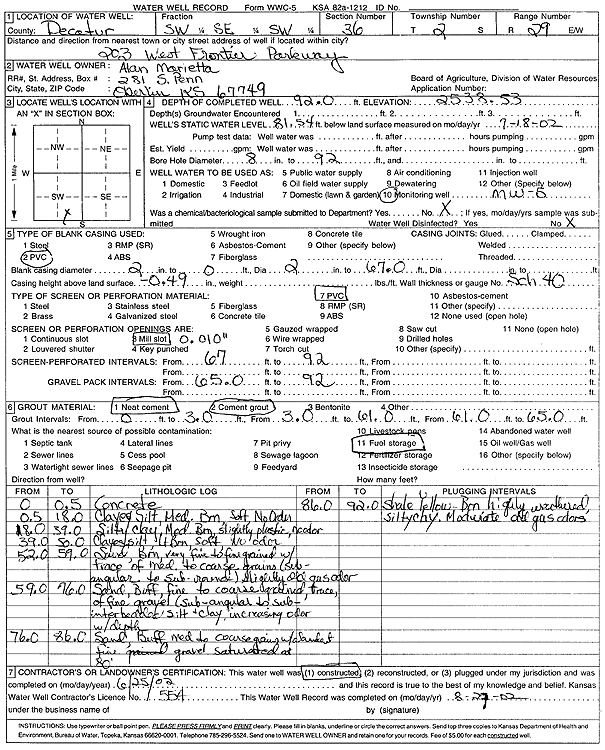
Specific Water Well Detail |
|
|
| Location Info | |||
| Owner: Marietta, Alan | Status: Constructed | ||
| Location: T2S, R29W, Sec. 36, SW SE SW | County: Decatur | ||
| Directions: 203 W Frontier Parkway | |||
| Latitude: 39.8289081 | Longitude: -100.5279789 | Datum NAD 27 | |
| Latitude: 39.8289133 | Longitude: -100.5284023 | Datum NAD 83 | |
| Longitude and latitude calculated by Survey from township-range-section-quarter calls. Only good to within the quarter call accuracy. | |||
| View well on interactive map | |||
| General Info | ||
| Well Depth: 92 ft. | Elevation: 2538.53 ft. | |
| Static Water Level: 81.54 ft. | Est. Yield: gpm. | |
| Comp. Date: 25-Jun-2002 | Well Use: Monitoring well/observation/piezometer | |
| DWR Applic. #: | Other ID: MW 5 | |
| Driller Info | ||
| Driller: Jay C. Woofter Pump & Well, Inc. | License #: 554 | |
| Scanned Form | View scan |
|
Chemical Sample Submitted?:
Water Well disinfected?: | ||
| Casing Info | ||
| Casing Type:
Casing Joints: |
Diam: in. to ft | |
| Casing height above land surface: in
Casing Weight: lbs/ft Wall thickness or gauge no.: | ||
| Screen and Perforation Info | ||
| Screen Type: | Screen Openings: | |
| Screen-perforated intervals | From: ft to ft | |
| Gravel pack intervals | From: ft to ft | |
| Grout Info | ||
| Grout used: | From: to ft | |
| Source of Possible Contamination | ||
| Source: | ||
| Direction from well: | Distance: ft | |
| Lithologic Log
(Log data entered by KGS.) | ||
| From: 0 ft. to .5 ft. | concrete | |
| From: .5 ft. to 18 ft. | clayey silt, medium brown, soft, no odor | |
| From: 18 ft. to 39 ft. | silty clay, medium brown slightly plastic, no odor | |
| From: 39 ft. to 50 ft. | clays, silt, light brown, soft, no odor | |
| From: 52 ft. to 59 ft. | sand, brown very fine to fine grained with trace of medium to coarse grains (sub-angular to sub-rounded) light gas odor | |
| From: 59 ft. to 76 ft. | sand, buff, fine to coarse grained, trace of fine gravel (sub-angular to sub-rounded) silt and clay, increasing odor with depth | |
| From: 76 ft. to 86 ft. | sand, buff medium to coarse grained with abundant fine grained gravel saturated at 80 feet | |
| From: 86 ft. to 92 ft. | shale yellow-brown, highly weathered, silty clay, moderate gas odors | |