|
|
|
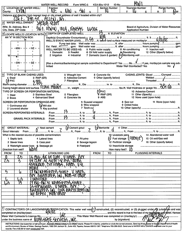
Specific Water Well Detail |
|
|
| Location Info | |||
| Owner: Scott, Jacque | Status: Constructed | ||
| Location: T16S, R11E, Sec. 14, NE NW SW | County: Lyon | ||
| Directions: 229 E 8th St, Allen | |||
| Latitude: 38.6579348 | Longitude: -96.1660047 | Datum NAD 27 | |
| Latitude: 38.6579428 | Longitude: -96.1662775 | Datum NAD 83 | |
| Longitude and latitude calculated by Survey from township-range-section-quarter calls. Only good to within the quarter call accuracy. | |||
| View well on interactive map | |||
| General Info | ||
| Well Depth: 13 ft. | Elevation: ft. | |
| Static Water Level: 11.53 ft. | Est. Yield: gpm. | |
| Comp. Date: 09-Sep-2002 | Well Use: Monitoring well/observation/piezometer | |
| DWR Applic. #: | Other ID: MW 1 | |
| Driller Info | ||
| Driller: Quad State Services, Inc. | License #: 692 | |
| Scanned Form | View scan |
|
Chemical Sample Submitted?:
Water Well disinfected?: | ||
| Casing Info | ||
| Casing Type:
Casing Joints: |
Diam: in. to ft | |
| Casing height above land surface: in
Casing Weight: lbs/ft Wall thickness or gauge no.: | ||
| Screen and Perforation Info | ||
| Screen Type: | Screen Openings: | |
| Screen-perforated intervals | From: ft to ft | |
| Gravel pack intervals | From: ft to ft | |
| Grout Info | ||
| Grout used: | From: to ft | |
| Source of Possible Contamination | ||
| Source: | ||
| Direction from well: | Distance: ft | |
| Lithologic Log
(Log data entered by KGS.) | ||
| From: 0 ft. to 2.5 ft. | limestone aggregate, dark gray clay, very hard, dry | |
| From: 2.5 ft. to 5 ft. | gray clay, slightly silty, scattered red oxide staining, chert fragments, hard, very slightly moist | |
| From: 5 ft. to 6 ft. | light brown weathered shale, very hard, dry, discolored brown, moderate-slight odor | |
| From: 6 ft. to 6.5 ft. | limestone | |
| From: 6.5 ft. to 13 ft. | light brown-brown slightly weathered shale, limestone stringers, very hard, dry, discolored brown, less discoloration with depth, moderate odor | |