|
|
|
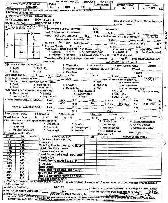
Specific Water Well Detail |
|
|
| Location Info | |||
| Owner: Davis, Steve | Status: Constructed | ||
| Location: T33S, R38W, Sec. 13, NE NW NE | County: Stevens | ||
| Directions: from Hugoton: 2.25 mi W | |||
| Latitude: 37.1836717 | Longitude: -101.3983168 | Datum NAD 27 | |
| Latitude: 37.1836965 | Longitude: -101.3987527 | Datum NAD 83 | |
| Longitude and latitude calculated by Survey from township-range-section-quarter calls. Only good to within the quarter call accuracy. | |||
| View well on interactive map | |||
| General Info | ||
| Well Depth: 510 ft. | Elevation: ft. | |
| Static Water Level: 160 ft. | Est. Yield: 50 gpm. | |
| Comp. Date: 02-Oct-2002 | Well Use: Domestic | |
| DWR Applic. #: | Other ID: | |
| Driller Info | ||
| Driller: Destal Tyler Water Well Service | License #: 473 | |
| Scanned Form | View scan |
|
Chemical Sample Submitted?:
Water Well disinfected?: | ||
| Casing Info | ||
| Casing Type:
Casing Joints: |
Diam: in. to ft | |
| Casing height above land surface: in
Casing Weight: lbs/ft Wall thickness or gauge no.: | ||
| Screen and Perforation Info | ||
| Screen Type: | Screen Openings: | |
| Screen-perforated intervals | From: ft to ft | |
| Gravel pack intervals | From: ft to ft | |
| Grout Info | ||
| Grout used: | From: to ft | |
| Source of Possible Contamination | ||
| Source: | ||
| Direction from well: | Distance: ft | |
| Lithologic Log
(Log data entered by KGS.) | ||
| From: 0 ft. to 15 ft. | fine sand and sandy clay | |
| From: 15 ft. to 70 ft. | fine sand | |
| From: 70 ft. to 115 ft. | caliche, fine to medium sand, little clay | |
| From: 115 ft. to 135 ft. | sand, medium to coarse | |
| From: 135 ft. to 161 ft. | brown sandy clay | |
| From: 161 ft. to 172 ft. | sand and cemented sand, medium-coarse | |
| From: 172 ft. to 175 ft. | sandy clay | |
| From: 175 ft. to 268 ft. | sand, fine to medium; little clay | |
| From: 268 ft. to 308 ft. | blue clay | |
| From: 308 ft. to 315 ft. | sandstone | |
| From: 315 ft. to 435 ft. | sand, fine to coarse; little clay | |
| From: 435 ft. to 455 ft. | brown sandy clay | |
| From: 455 ft. to 504 ft. | sand and small gravel; medium to coarse | |
| From: 504 ft. to 515 ft. | red sandstone, hard | |