|
|
|
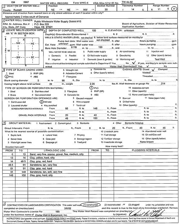
Specific Water Well Detail |
|
|
| Location Info | |||
| Owner: Public Wholesale Water Supply District 15 | Status: Constructed | ||
| Location: T14S, R11W, Sec. 30, NE NE NW | County: Russell | ||
| Directions: from Dorrance: 2 mi S | |||
| Latitude: 38.812036 | Longitude: -98.5866625 | Datum NAD 27 | |
| Latitude: 38.812047 | Longitude: -98.5870117 | Datum NAD 83 | |
| Longitude and latitude calculated by Survey from township-range-section-quarter calls. Only good to within the quarter call accuracy. | |||
| View well on interactive map | |||
| General Info | ||
| Well Depth: 150 ft. | Elevation: ft. | |
| Static Water Level: ft. | Est. Yield: gpm. | |
| Comp. Date: 06-Mar-2002 | Well Use: Test hole/well | |
| DWR Applic. #: | Other ID: TW 44-02 | |
| Driller Info | ||
| Driller: Clarke Well and Equipment, Inc. | License #: 185 | |
| Scanned Form | View scan |
|
Chemical Sample Submitted?:
Water Well disinfected?: | ||
| Casing Info | ||
| Casing Type:
Casing Joints: |
Diam: in. to ft | |
| Casing height above land surface: in
Casing Weight: lbs/ft Wall thickness or gauge no.: | ||
| Screen and Perforation Info | ||
| Screen Type: | Screen Openings: | |
| Screen-perforated intervals | From: ft to ft | |
| Gravel pack intervals | From: ft to ft | |
| Grout Info | ||
| Grout used: | From: to ft | |
| Source of Possible Contamination | ||
| Source: | ||
| Direction from well: | Distance: ft | |
| Lithologic Log
(Log data entered by KGS.) | ||
| From: 0 ft. to 13 ft. | very fine-coarse sand and fine-medium gravel, silty | |
| From: 13 ft. to 14 ft. | silty clay, yellow, hard | |
| From: 14 ft. to 46.5 ft. | clay, gray, red, hard | |
| From: 46.5 ft. to 61 ft. | very fine sandstone, tan | |
| From: 61 ft. to 91 ft. | clay, gray, red, hard | |
| From: 91 ft. to 148 ft. | very fine sandstone, tan, soft | |
| From: 148 ft. to 150 ft. | silty clay, gray, hard | |