|
|
|
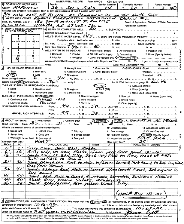
Specific Water Well Detail |
|
|
| Location Info | |||
| Owner: Kansas Corporation Commission | Status: Constructed | ||
| Location: T20S, R3W, Sec. 24, SE SW SW | County: McPherson | ||
| Directions: from Elyria: .75 mi E on Commanche Rd, N side | |||
| Latitude: 38.2904966 | Longitude: -97.6080037 | Datum NAD 27 | |
| Latitude: 38.2905053 | Longitude: -97.6083231 | Datum NAD 83 | |
| Longitude and latitude calculated by Survey from township-range-section-quarter calls. Only good to within the quarter call accuracy. | |||
| View well on interactive map | |||
| General Info | ||
| Well Depth: 50 ft. | Elevation: ft. | |
| Static Water Level: 13.5 ft. | Est. Yield: gpm. | |
| Comp. Date: 16-Jul-2002 | Well Use: Monitoring well/observation/piezometer | |
| DWR Applic. #: | Other ID: Ely 10-02 | |
| Driller Info | ||
| Driller: Pratt Well Service, Inc. | License #: 665 | |
| Scanned Form | View scan |
|
Chemical Sample Submitted?:
Water Well disinfected?: | ||
| Casing Info | ||
| Casing Type:
Casing Joints: |
Diam: in. to ft | |
| Casing height above land surface: in
Casing Weight: lbs/ft Wall thickness or gauge no.: | ||
| Screen and Perforation Info | ||
| Screen Type: | Screen Openings: | |
| Screen-perforated intervals | From: ft to ft | |
| Gravel pack intervals | From: ft to ft | |
| Grout Info | ||
| Grout used: | From: to ft | |
| Source of Possible Contamination | ||
| Source: | ||
| Direction from well: | Distance: ft | |
| Lithologic Log
(Log data entered by KGS.) | ||
| From: 0 ft. to 6 ft. | silty clay, dark brown, plastic | |
| From: 6 ft. to 16 ft. | silty clay, light brown, plastic, trace very fine sand at 14-16 feet | |
| From: 16 ft. to 31 ft. | sandy clay, light brown, silty, very fine to fine sand, trace medium, subrounded to round | |
| From: 31 ft. to 36 ft. | fine to medium sand with some coarse, orange brown, subrounded to subangular, with clay and silt seams | |
| From: 36 ft. to 41 ft. | medium to coarse sand with moderate fine, orange brown, subangular to subrounded | |
| From: 41 ft. to 44 ft. | fine to coarse sand, brown, quartzite cemented, sandstone nodules | |
| From: 44 ft. to 50 ft. | weathered shale, gray, yellow streaks | |
| From: 50 ft. to 55 ft. | silty shale, gray green, few yellow zones | |