|
|
|
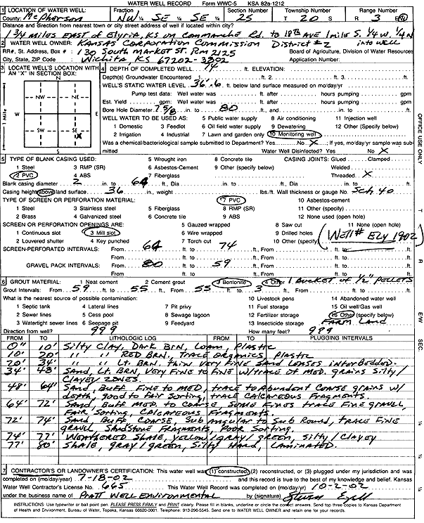
Specific Water Well Detail |
|
|
| Location Info | |||
| Owner: Kansas Corporation Commission | Status: Constructed | ||
| Location: T20S, R3W, Sec. 25, NW SE SE | County: McPherson | ||
| Directions: from Elyria: 1.75 mi E on Commanche Rd to 18th Ave, 1 mi S, .25 mi W, .25 mi N | |||
| Latitude: 38.2779233 | Longitude: -97.5961996 | Datum NAD 27 | |
| Latitude: 38.2779321 | Longitude: -97.5965189 | Datum NAD 83 | |
| Longitude and latitude calculated by Survey from township-range-section-quarter calls. Only good to within the quarter call accuracy. | |||
| View well on interactive map | |||
| General Info | ||
| Well Depth: 74 ft. | Elevation: ft. | |
| Static Water Level: 36.5 ft. | Est. Yield: gpm. | |
| Comp. Date: 18-Jul-2002 | Well Use: Monitoring well/observation/piezometer | |
| DWR Applic. #: | Other ID: Ely 19-02 | |
| Driller Info | ||
| Driller: Pratt Well Service, Inc. | License #: 665 | |
| Scanned Form | View scan |
|
Chemical Sample Submitted?:
Water Well disinfected?: | ||
| Casing Info | ||
| Casing Type:
Casing Joints: |
Diam: in. to ft | |
| Casing height above land surface: in
Casing Weight: lbs/ft Wall thickness or gauge no.: | ||
| Screen and Perforation Info | ||
| Screen Type: | Screen Openings: | |
| Screen-perforated intervals | From: ft to ft | |
| Gravel pack intervals | From: ft to ft | |
| Grout Info | ||
| Grout used: | From: to ft | |
| Source of Possible Contamination | ||
| Source: | ||
| Direction from well: | Distance: ft | |
| Lithologic Log
(Log data entered by KGS.) | ||
| From: 0 ft. to 10 ft. | silty clay, dark brown, loam, plastic | |
| From: 10 ft. to 20 ft. | silty clay, red brown, trace organics, plastic | |
| From: 20 ft. to 34 ft. | silty clay, light brown, thin very fine sand lenses interbedded | |
| From: 34 ft. to 48 ft. | sand, light brown, very fine to fine with trace of medium, silty-clayey zones | |
| From: 48 ft. to 64 ft. | sand, buff, fine to medium, trace to abundant coarse with depth, good to fair sorting, trace calcareous fragments | |
| From: 64 ft. to 72 ft. | sand, buff, medium to coarse, some fine, trace fine gravel, fair sorting, calcareous fragments | |
| From: 72 ft. to 74 ft. | sand, buff, coarse, sub angular to sub round, trace fine gravel, sandstone fragments, poor sorting | |
| From: 74 ft. to 77 ft. | weathered shale, yellow-gray-green, silty/clayey | |
| From: 77 ft. to 80 ft. | shale, gray-green, silty, hard, laminated | |