|
|
|
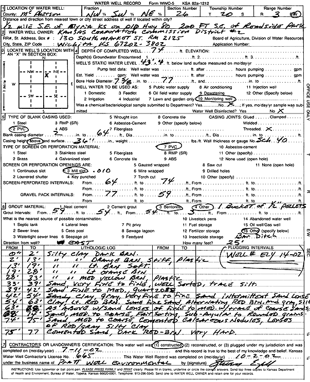
Specific Water Well Detail |
|
|
| Location Info | |||
| Owner: Kansas Corporation Commission | Status: Constructed | ||
| Location: T20S, R3W, Sec. 26, NW SW NE | County: McPherson | ||
| Directions: from Elyria: .5 mi SE on old Hwy 80, 200' SE of Park | |||
| Latitude: 38.2851475 | Longitude: -97.619517 | Datum NAD 27 | |
| Latitude: 38.2851562 | Longitude: -97.6198369 | Datum NAD 83 | |
| Longitude and latitude calculated by Survey from township-range-section-quarter calls. Only good to within the quarter call accuracy. | |||
| View well on interactive map | |||
| General Info | ||
| Well Depth: 74 ft. | Elevation: ft. | |
| Static Water Level: 43.33 ft. | Est. Yield: gpm. | |
| Comp. Date: 11-Jul-2002 | Well Use: Monitoring well/observation/piezometer | |
| DWR Applic. #: | Other ID: Ely 14-02 | |
| Driller Info | ||
| Driller: Pratt Well Service, Inc. | License #: 665 | |
| Scanned Form | View scan |
|
Chemical Sample Submitted?:
Water Well disinfected?: | ||
| Casing Info | ||
| Casing Type:
Casing Joints: |
Diam: in. to ft | |
| Casing height above land surface: in
Casing Weight: lbs/ft Wall thickness or gauge no.: | ||
| Screen and Perforation Info | ||
| Screen Type: | Screen Openings: | |
| Screen-perforated intervals | From: ft to ft | |
| Gravel pack intervals | From: ft to ft | |
| Grout Info | ||
| Grout used: | From: to ft | |
| Source of Possible Contamination | ||
| Source: | ||
| Direction from well: | Distance: ft | |
| Lithologic Log
(Log data entered by KGS.) | ||
| From: 0 ft. to 2 ft. | silty clay, dark brown | |
| From: 2 ft. to 13 ft. | silty clay, orange brown, stiff, plastic | |
| From: 13 ft. to 19 ft. | silty clay, light brown, soft | |
| From: 19 ft. to 28 ft. | silty clay, light orange brown | |
| From: 28 ft. to 33 ft. | silty clay, moderate yellow brown, plastic | |
| From: 33 ft. to 39 ft. | very fine to fine sand, well sorted, trace silt | |
| From: 39 ft. to 42 ft. | fine to medium sand, quartzose | |
| From: 42 ft. to 54 ft. | very fine to fine sandy clay, gray, intermittent sand lenses | |
| From: 54 ft. to 63 ft. | clay, light red brown, some fine sand, alternating red brown and gray, silt | |
| From: 63 ft. to 68 ft. | clay, light red brown, some fine sand, alternating red brown and gray, silt | |
| From: 68 ft. to 74 ft. | medium to coarse sand, fair sorting, subangular to rounded | |
| From: 74 ft. to 75 ft. | medium to coarse sand, cemented calcareous nodules, lenses of red-gray silty clay | |
| From: 75 ft. to 77 ft. | cemented sand, dark red brown, very hard | |