|
|
|
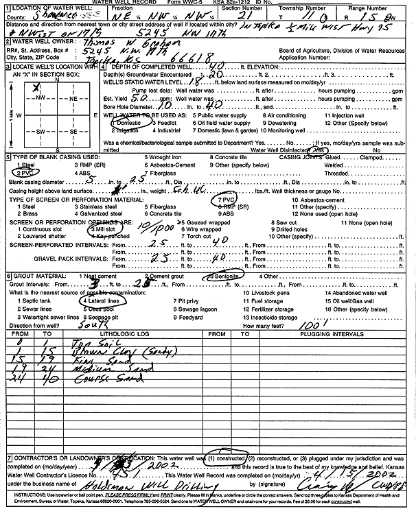
Specific Water Well Detail |
|
|
| Location Info | |||
| Owner: Graham, Thomas W | Status: Constructed | ||
| Location: T11S, R15E, Sec. 21, NE NW NW | County: Shawnee | ||
| Directions: 5245 NW 17th, Topeka - .5 mi W on Hwy 75, NW on 17th, Topeka | |||
| Latitude: 39.0862363 | Longitude: -95.758164 | Datum NAD 27 | |
| Latitude: 39.086236 | Longitude: -95.7584257 | Datum NAD 83 | |
| Longitude and latitude calculated by Survey from township-range-section-quarter calls. Only good to within the quarter call accuracy. | |||
| View well on interactive map | |||
| General Info | ||
| Well Depth: 40 ft. | Elevation: ft. | |
| Static Water Level: 18 ft. | Est. Yield: 50 gpm. | |
| Comp. Date: 03-Apr-2002 | Well Use: Domestic | |
| DWR Applic. #: | Other ID: | |
| Driller Info | ||
| Driller: Craig Haldeman Well Drilling & Pump Service | License #: 451 | |
| Scanned Form | View scan |
|
Chemical Sample Submitted?:
Water Well disinfected?: | ||
| Casing Info | ||
| Casing Type:
Casing Joints: |
Diam: in. to ft | |
| Casing height above land surface: in
Casing Weight: lbs/ft Wall thickness or gauge no.: | ||
| Screen and Perforation Info | ||
| Screen Type: | Screen Openings: | |
| Screen-perforated intervals | From: ft to ft | |
| Gravel pack intervals | From: ft to ft | |
| Grout Info | ||
| Grout used: | From: to ft | |
| Source of Possible Contamination | ||
| Source: | ||
| Direction from well: | Distance: ft | |
| Lithologic Log
(Log data entered by KGS.) | ||
| From: 0 ft. to 1 ft. | top soil | |
| From: 1 ft. to 15 ft. | sandy clay, brown | |
| From: 15 ft. to 19 ft. | fine sand | |
| From: 19 ft. to 24 ft. | medium sand | |
| From: 24 ft. to 40 ft. | coarse sand | |