|
|
|
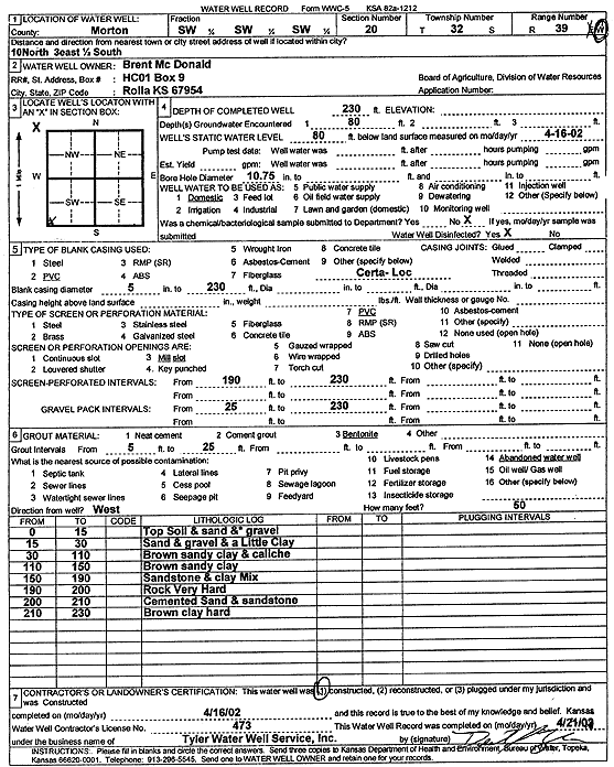
Specific Water Well Detail |
|
|
| Location Info | |||
| Owner: McDonald, Brent | Status: Constructed | ||
| Location: T32S, R39W, Sec. 20, SW SW SW | County: Morton | ||
| Directions: From Rolla, 10 miles North, 3 miles East, and 0.5 mile South | |||
| Latitude: 37.2440031 | Longitude: -101.5911754 | Datum NAD 27 | |
| Latitude: 37.2440272 | Longitude: -101.5916136 | Datum NAD 83 | |
| Longitude and latitude calculated by Survey from township-range-section-quarter calls. Only good to within the quarter call accuracy. | |||
| View well on interactive map | |||
| General Info | ||
| Well Depth: 230 ft. | Elevation: ft. | |
| Static Water Level: 80 ft. | Est. Yield: gpm. | |
| Comp. Date: 16-Apr-2002 | Well Use: Domestic | |
| DWR Applic. #: | Other ID: | |
| Driller Info | ||
| Driller: Destal Tyler Water Well Service | License #: 473 | |
| Scanned Form | View scan |
|
Chemical Sample Submitted?:
Water Well disinfected?: | ||
| Casing Info | ||
| Casing Type:
Casing Joints: |
Diam: in. to ft | |
| Casing height above land surface: in
Casing Weight: lbs/ft Wall thickness or gauge no.: | ||
| Screen and Perforation Info | ||
| Screen Type: | Screen Openings: | |
| Screen-perforated intervals | From: ft to ft | |
| Gravel pack intervals | From: ft to ft | |
| Grout Info | ||
| Grout used: | From: to ft | |
| Source of Possible Contamination | ||
| Source: | ||
| Direction from well: | Distance: ft | |
| Lithologic Log
(Log data entered by KGS.) | ||
| From: 0 ft. to 15 ft. | topsoil and sand and gravel | |
| From: 15 ft. to 30 ft. | sand and gravel and a little clay | |
| From: 30 ft. to 110 ft. | brown sandy clay and caliche | |
| From: 110 ft. to 150 ft. | brown sandy clay | |
| From: 150 ft. to 190 ft. | sandstone and clay mix | |
| From: 190 ft. to 200 ft. | rock very hard | |
| From: 200 ft. to 210 ft. | cemented sand and sandstone | |
| From: 210 ft. to 230 ft. | brown clay hard | |