|
|
|
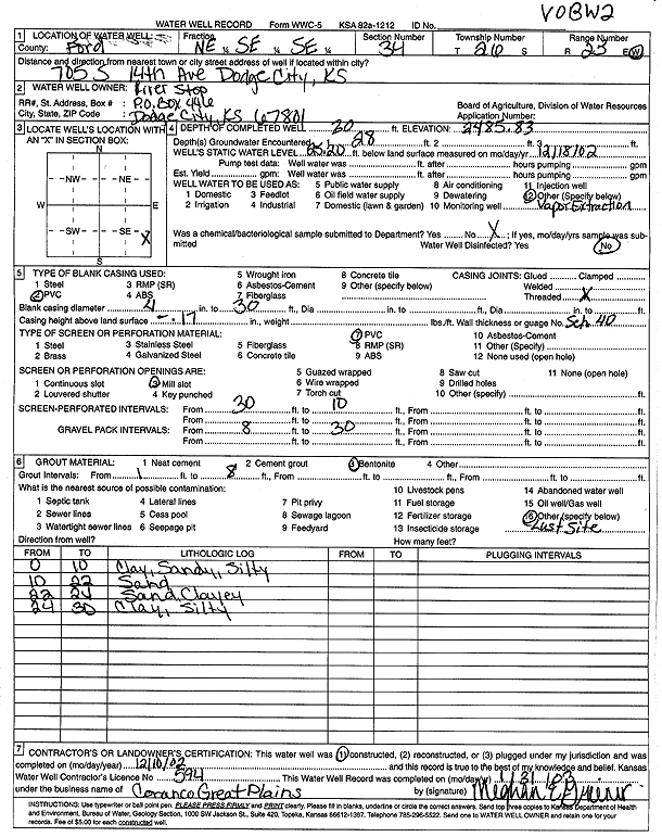
Specific Water Well Detail |
|
|
| Location Info | |||
| Owner: River Stop | Status: Constructed | ||
| Location: T26S, R25W, Sec. 34, NE SE SE | County: Ford | ||
| Directions: 705 S 14th Ave, Dodge City | |||
| Latitude: 37.7391056 | Longitude: -100.0339413 | Datum NAD 27 | |
| Latitude: 37.7391262 | Longitude: -100.034354 | Datum NAD 83 | |
| Longitude and latitude calculated by Survey from township-range-section-quarter calls. Only good to within the quarter call accuracy. | |||
| View well on interactive map | |||
| General Info | ||
| Well Depth: 30 ft. | Elevation: 2485.83 ft. | |
| Static Water Level: 25.2 ft. | Est. Yield: gpm. | |
| Comp. Date: 10-Dec-2002 | Well Use: Recovery/Soil Vapor Extraction/Soil Vent | |
| DWR Applic. #: | Other ID: VOBW 2 | |
| Driller Info | ||
| Driller: Coranco Great Plains, Inc. | License #: 594 | |
| Scanned Form | View scan |
|
Chemical Sample Submitted?:
Water Well disinfected?: | ||
| Casing Info | ||
| Casing Type:
Casing Joints: |
Diam: in. to ft | |
| Casing height above land surface: in
Casing Weight: lbs/ft Wall thickness or gauge no.: | ||
| Screen and Perforation Info | ||
| Screen Type: | Screen Openings: | |
| Screen-perforated intervals | From: ft to ft | |
| Gravel pack intervals | From: ft to ft | |
| Grout Info | ||
| Grout used: | From: to ft | |
| Source of Possible Contamination | ||
| Source: | ||
| Direction from well: | Distance: ft | |
| Lithologic Log
(Log data entered by KGS.) | ||
| From: 0 ft. to 10 ft. | clay, sandy, silty | |
| From: 10 ft. to 22 ft. | sand | |
| From: 22 ft. to 24 ft. | sand clayey | |
| From: 24 ft. to 30 ft. | clay, silty | |