|
|
|
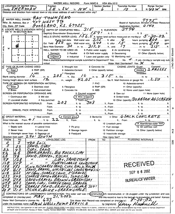
Specific Water Well Detail |
|
|
| Location Info | |||
| Owner: Townsend, Ray | Status: Constructed | ||
| Location: T10S, R40W, Sec. 6, SE SW NW | County: Sherman | ||
| Directions: | |||
| Latitude: 39.2138794 | Longitude: -101.8344166 | Datum NAD 27 | |
| Latitude: 39.2138814 | Longitude: -101.8348696 | Datum NAD 83 | |
| Longitude and latitude calculated by Survey from township-range-section-quarter calls. Only good to within the quarter call accuracy. | |||
| View well on interactive map | |||
| General Info | ||
| Well Depth: 315 ft. | Elevation: 3790 ft. | |
| Static Water Level: 156.5 ft. | Est. Yield: 850 gpm. | |
| Comp. Date: 31-May-2002 | Well Use: Irrigation | |
| DWR Applic. #: 7775 | Other ID: | |
| Links | |
| No Wizard information available. | |
| View info from WIMAS Water Right Data base... | |
| Driller Info | ||
| Driller: DMW Well & Pump Service | License #: 633 | |
| Scanned Form | View scan |
|
Chemical Sample Submitted?:
Water Well disinfected?: | ||
| Casing Info | ||
| Casing Type:
Casing Joints: |
Diam: in. to ft | |
| Casing height above land surface: in
Casing Weight: lbs/ft Wall thickness or gauge no.: | ||
| Screen and Perforation Info | ||
| Screen Type: | Screen Openings: | |
| Screen-perforated intervals | From: ft to ft | |
| Gravel pack intervals | From: ft to ft | |
| Grout Info | ||
| Grout used: | From: to ft | |
| Source of Possible Contamination | ||
| Source: | ||
| Direction from well: | Distance: ft | |
| Lithologic Log
(Log data entered by KGS.) | ||
| From: 0 ft. to 3 ft. | Top soil | |
| From: 3 ft. to 22 ft. | Sand, clay | |
| From: 22 ft. to 42 ft. | Clay, sand | |
| From: 42 ft. to 68 ft. | Sand, gravel, big rocks, clay | |
| From: 68 ft. to 98 ft. | Sand, gravel, rocks | |
| From: 98 ft. to 128 ft. | Sand, gravel, clay, sandstone | |
| From: 128 ft. to 158 ft. | Sand, gravel, fine to coarse sandstone | |
| From: 158 ft. to 188 ft. | Fine to coarse sand, clay, black rock | |
| From: 188 ft. to 218 ft. | Sand, gravel, white clay, sandstone | |
| From: 218 ft. to 233 ft. | Clay, coarse sand, gravel | |
| From: 233 ft. to 248 ft. | Coarse sand and gravel, some clay | |
| From: 248 ft. to 278 ft. | Sand and gravel; brown and green clay | |
| From: 278 ft. to 293 ft. | Sand, clay, coarse sand, gravel | |
| From: 293 ft. to 308 ft. | Coarse sand, gravel, ochre | |
| From: 308 ft. to 315 ft. | Ochre, blue and green shale | |