|
|
|
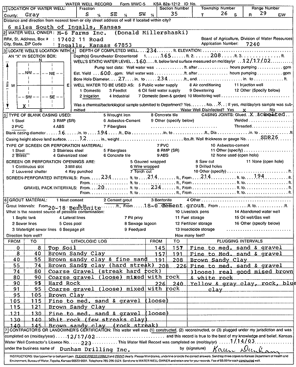
Specific Water Well Detail |
|
|
| Location Info | |||
| Owner: Millershaski, Don | Status: Constructed | ||
| Location: T26S, R29W, Sec. 35, S2 SE SW | County: Gray | ||
| Directions: from Ingalls: 6 mi S | |||
| Latitude: 37.7381342 | Longitude: -100.4627603 | Datum NAD 27 | |
| Latitude: 37.7381567 | Longitude: -100.4631875 | Datum NAD 83 | |
| Longitude and latitude calculated by Survey from township-range-section-quarter calls. Only good to within the quarter call accuracy. | |||
| View well on interactive map | |||
| General Info | ||
| Well Depth: 234 ft. | Elevation: ft. | |
| Static Water Level: 160 ft. | Est. Yield: 600 gpm. | |
| Comp. Date: 17-Dec-2002 | Well Use: Irrigation | |
| DWR Applic. #: 7240 | Other ID: | |
| Links | |
| No Wizard information available. | |
| View info from WIMAS Water Right Data base... | |
| Driller Info | ||
| Driller: Donald R. Dunham Drilling, Inc. | License #: 223 | |
| Scanned Form | View scan |
|
Chemical Sample Submitted?:
Water Well disinfected?: | ||
| Casing Info | ||
| Casing Type:
Casing Joints: |
Diam: in. to ft | |
| Casing height above land surface: in
Casing Weight: lbs/ft Wall thickness or gauge no.: | ||
| Screen and Perforation Info | ||
| Screen Type: | Screen Openings: | |
| Screen-perforated intervals | From: ft to ft | |
| Gravel pack intervals | From: ft to ft | |
| Grout Info | ||
| Grout used: | From: to ft | |
| Source of Possible Contamination | ||
| Source: | ||
| Direction from well: | Distance: ft | |
| Lithologic Log
(Log data entered by KGS.) | ||
| From: 0 ft. to 8 ft. | Top Soil | |
| From: 8 ft. to 40 ft. | Brown Sandy Clay | |
| From: 40 ft. to 55 ft. | Brown sandy clay and fine sand | |
| From: 55 ft. to 74 ft. | Brown Sandy clay (hard streak) | |
| From: 74 ft. to 80 ft. | Coarse Gravel (streak hard rock) | |
| From: 80 ft. to 90 ft. | Coarse gravel (loose) mixed with rock | |
| From: 90 ft. to 91 ft. | Hard Rock | |
| From: 91 ft. to 95 ft. | Coarse gravel (loose) mixed with rock | |
| From: 95 ft. to 105 ft. | Brown Clay | |
| From: 105 ft. to 115 ft. | Fine to medium sand and gravel (loose) | |
| From: 115 ft. to 121 ft. | Brown Sandy Clay | |
| From: 121 ft. to 130 ft. | Fine to medium sand and gravel (loose) | |
| From: 130 ft. to 140 ft. | Whit rock (few streaks clay) | |
| From: 140 ft. to 145 ft. | Brown sandy clay (rock streak) | |
| From: 145 ft. to 157 ft. | Fine to medium sand and gravel | |
| From: 157 ft. to 191 ft. | Fine to medium sand and gravel | |
| From: 191 ft. to 208 ft. | Brown Sandy Clay | |
| From: 208 ft. to 226 ft. | Fine to medium sand and gravel (loose) real good mixed brown and white rock | |
| From: 226 ft. to 240 ft. | Yellow and gray clay, rock, blue clay | |