|
|
|
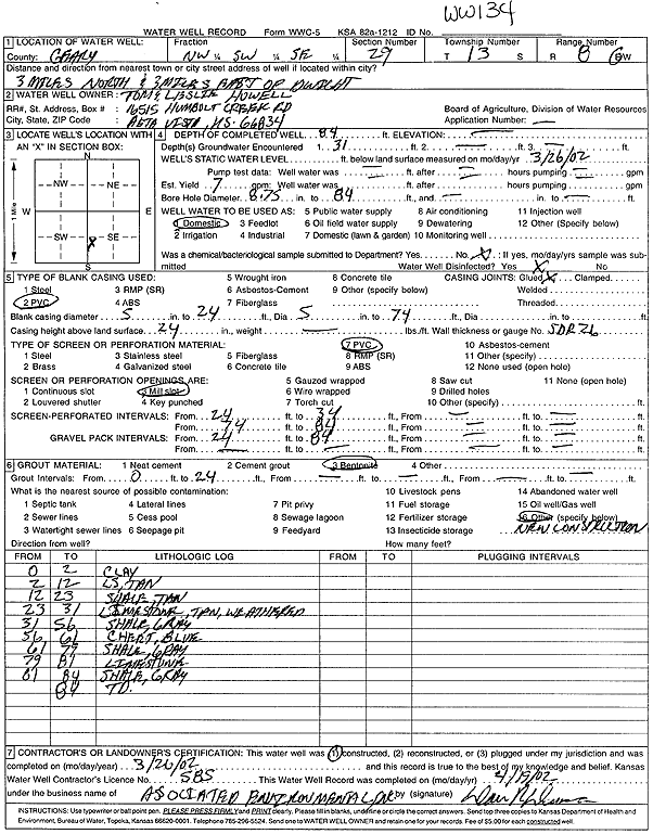
Specific Water Well Detail |
|
|
| Location Info | |||
| Owner: Howell, Tom and Leslie | Status: Constructed | ||
| Location: T13S, R8E, Sec. 29, NW SW SE | County: Geary | ||
| Directions: from Dwight: 3 mi N, 3 mi E | |||
| Latitude: 38.8871283 | Longitude: -96.5466363 | Datum NAD 27 | |
| Latitude: 38.8871304 | Longitude: -96.5469165 | Datum NAD 83 | |
| Longitude and latitude calculated by Survey from township-range-section-quarter calls. Only good to within the quarter call accuracy. | |||
| View well on interactive map | |||
| General Info | ||
| Well Depth: 84 ft. | Elevation: ft. | |
| Static Water Level: ft. | Est. Yield: 7 gpm. | |
| Comp. Date: 26-Mar-2002 | Well Use: Domestic | |
| DWR Applic. #: | Other ID: WW 134 | |
| Driller Info | ||
| Driller: Associated Environmental, Inc. | License #: 585 | |
| Scanned Form | View scan |
|
Chemical Sample Submitted?:
Water Well disinfected?: | ||
| Casing Info | ||
| Casing Type:
Casing Joints: |
Diam: in. to ft | |
| Casing height above land surface: in
Casing Weight: lbs/ft Wall thickness or gauge no.: | ||
| Screen and Perforation Info | ||
| Screen Type: | Screen Openings: | |
| Screen-perforated intervals | From: ft to ft | |
| Gravel pack intervals | From: ft to ft | |
| Grout Info | ||
| Grout used: | From: to ft | |
| Source of Possible Contamination | ||
| Source: | ||
| Direction from well: | Distance: ft | |
| Lithologic Log
(Log data entered by KGS.) | ||
| From: 0 ft. to 2 ft. | clay | |
| From: 2 ft. to 12 ft. | limestone, tan | |
| From: 12 ft. to 23 ft. | shale, tan | |
| From: 23 ft. to 31 ft. | weathered limestone, tan | |
| From: 31 ft. to 56 ft. | shale, gray | |
| From: 56 ft. to 61 ft. | chert, blue | |
| From: 61 ft. to 79 ft. | shale, gray | |
| From: 79 ft. to 81 ft. | limestone | |
| From: 81 ft. to 84 ft. | shale, gray | |