|
|
|
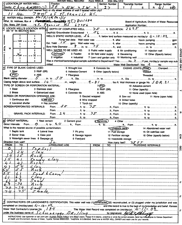
Specific Water Well Detail |
|
|
| Location Info | |||
| Owner: Mills, Patrick | Status: Constructed | ||
| Location: T1S, R41W, Sec. 27, SE NW SW | County: Cheyenne | ||
| Directions: from St. Francis: 11 mi N, 7 mi W | |||
| Latitude: 39.9351379 | Longitude: -101.9134043 | Datum NAD 27 | |
| Latitude: 39.9351296 | Longitude: -101.9138624 | Datum NAD 83 | |
| Longitude and latitude calculated by Survey from township-range-section-quarter calls. Only good to within the quarter call accuracy. | |||
| View well on interactive map | |||
| General Info | ||
| Well Depth: 75 ft. | Elevation: 3625 ft. | |
| Static Water Level: 56 ft. | Est. Yield: 15 gpm. | |
| Comp. Date: 10-Apr-2002 | Well Use: Domestic | |
| DWR Applic. #: | Other ID: | |
| Driller Info | ||
| Driller: Schoenrogge Drilling, Inc. | License #: 184 | |
| Scanned Form | View scan |
|
Chemical Sample Submitted?:
Water Well disinfected?: | ||
| Casing Info | ||
| Casing Type:
Casing Joints: |
Diam: in. to ft | |
| Casing height above land surface: in
Casing Weight: lbs/ft Wall thickness or gauge no.: | ||
| Screen and Perforation Info | ||
| Screen Type: | Screen Openings: | |
| Screen-perforated intervals | From: ft to ft | |
| Gravel pack intervals | From: ft to ft | |
| Grout Info | ||
| Grout used: | From: to ft | |
| Source of Possible Contamination | ||
| Source: | ||
| Direction from well: | Distance: ft | |
| Lithologic Log
(Log data entered by KGS.) | ||
| From: 0 ft. to 3 ft. | Topsoil | |
| From: 3 ft. to 34 ft. | Clay | |
| From: 34 ft. to 35 ft. | Rock | |
| From: 35 ft. to 41 ft. | Sandy clay | |
| From: 41 ft. to 43 ft. | Rock | |
| From: 43 ft. to 54 ft. | Clay | |
| From: 54 ft. to 55 ft. | Rock | |
| From: 55 ft. to 61 ft. | Sand and gravel | |
| From: 61 ft. to 63 ft. | Clay | |
| From: 63 ft. to 69 ft. | Sand | |
| From: 69 ft. to 70 ft. | Rock | |
| From: 70 ft. to 74 ft. | Sand | |
| From: 74 ft. to 75 ft. | Shale | |