|
|
|
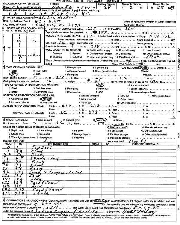
Specific Water Well Detail |
|
|
| Location Info | |||
| Owner: Beeson, Mrs. Lee | Status: Constructed | ||
| Location: T2S, R38W, Sec. 28, NW SE SW | County: Cheyenne | ||
| Directions: from Bend City: 6 mi N, 3 mi W | |||
| Latitude: 39.8464915 | Longitude: -101.5911268 | Datum NAD 27 | |
| Latitude: 39.8464862 | Longitude: -101.5915726 | Datum NAD 83 | |
| Longitude and latitude calculated by Survey from township-range-section-quarter calls. Only good to within the quarter call accuracy. | |||
| View well on interactive map | |||
| General Info | ||
| Well Depth: 238 ft. | Elevation: 3600 ft. | |
| Static Water Level: 187 ft. | Est. Yield: 10 gpm. | |
| Comp. Date: 29-Apr-2002 | Well Use: Domestic, Livestock | |
| DWR Applic. #: | Other ID: | |
| Driller Info | ||
| Driller: Schoenrogge Drilling, Inc. | License #: 184 | |
| Scanned Form | View scan |
|
Chemical Sample Submitted?:
Water Well disinfected?: | ||
| Casing Info | ||
| Casing Type:
Casing Joints: |
Diam: in. to ft | |
| Casing height above land surface: in
Casing Weight: lbs/ft Wall thickness or gauge no.: | ||
| Screen and Perforation Info | ||
| Screen Type: | Screen Openings: | |
| Screen-perforated intervals | From: ft to ft | |
| Gravel pack intervals | From: ft to ft | |
| Grout Info | ||
| Grout used: | From: to ft | |
| Source of Possible Contamination | ||
| Source: | ||
| Direction from well: | Distance: ft | |
| Lithologic Log
(Log data entered by KGS.) | ||
| From: 0 ft. to 3 ft. | Topsoil | |
| From: 3 ft. to 49 ft. | Clay | |
| From: 49 ft. to 51 ft. | Rock | |
| From: 51 ft. to 68 ft. | Sandy clay | |
| From: 68 ft. to 70 ft. | Rock | |
| From: 70 ft. to 93 ft. | Sand | |
| From: 93 ft. to 96 ft. | Rock | |
| From: 96 ft. to 153 ft. | Sand with layers of clay | |
| From: 153 ft. to 181 ft. | Sand | |
| From: 181 ft. to 186 ft. | Clay | |
| From: 186 ft. to 189 ft. | Sand and gravel | |
| From: 189 ft. to 190 ft. | Rock | |
| From: 190 ft. to 237 ft. | Sand and gravel | |
| From: 237 ft. to 238 ft. | Shale | |