|
|
|
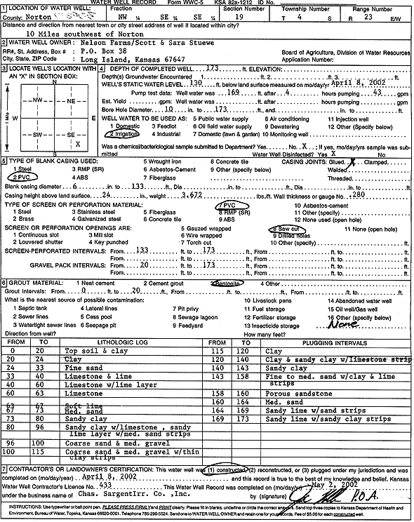
Specific Water Well Detail |
|
|
| Location Info | |||
| Owner: Nelson Farms/ Scott and Sara Stuewe | Status: Constructed | ||
| Location: T4S, R23W, Sec. 19, NW SE SE | County: Norton | ||
| Directions: from Norton: 10 mi SW | |||
| Latitude: 39.6855939 | Longitude: -99.949412 | Datum NAD 27 | |
| Latitude: 39.6855988 | Longitude: -99.9498148 | Datum NAD 83 | |
| Longitude and latitude calculated by Survey from township-range-section-quarter calls. Only good to within the quarter call accuracy. | |||
| View well on interactive map | |||
| General Info | ||
| Well Depth: 173 ft. | Elevation: ft. | |
| Static Water Level: 130 ft. | Est. Yield: gpm. | |
| Comp. Date: 08-Apr-2002 | Well Use: Irrigation | |
| DWR Applic. #: | Other ID: | |
| Links | |
| View info from Wizard Water Level Data base... | |
| View info from WIMAS Water Right Data base... | |
| Driller Info | ||
| Driller: Chas. Sargent Irrigation Co., Inc. | License #: 433 | |
| Scanned Form | View scan |
|
Chemical Sample Submitted?:
Water Well disinfected?: | ||
| Casing Info | ||
| Casing Type: PVC
Casing Joints: |
Diam: 6 in. to 133 ft | |
| Casing height above land surface: in
Casing Weight: lbs/ft Wall thickness or gauge no.: | ||
| Screen and Perforation Info | ||
| Screen Type: PVC | Screen Openings: | |
| Screen-perforated intervals | From: 133 ft to 173 ft | |
| Gravel pack intervals | From: ft to ft | |
| Grout Info | ||
| Grout used: | From: to ft | |
| Source of Possible Contamination | ||
| Source: | ||
| Direction from well: | Distance: ft | |
| Lithologic Log
(Log data entered by KGS.) | ||
| From: 0 ft. to 20 ft. | top soil and clay | |
| From: 20 ft. to 24 ft. | clay | |
| From: 24 ft. to 33 ft. | fine sand | |
| From: 33 ft. to 40 ft. | limestone and lime | |
| From: 40 ft. to 60 ft. | limestone with lime layer | |
| From: 60 ft. to 63 ft. | limestone | |
| From: 63 ft. to 67 ft. | soft lime | |
| From: 67 ft. to 73 ft. | medium sand | |
| From: 73 ft. to 80 ft. | sandy clay | |
| From: 80 ft. to 96 ft. | sandy clay with limestone, sandy lime layer with medium sand strips | |
| From: 96 ft. to 100 ft. | coarse sand and medium gravel | |
| From: 100 ft. to 115 ft. | coarse sand and medium gravel with thin clay strips | |
| From: 115 ft. to 120 ft. | clay | |
| From: 120 ft. to 140 ft. | clay and sandy clay with limestone strip | |
| From: 140 ft. to 143 ft. | sandy clay | |
| From: 143 ft. to 158 ft. | fine to medium sand with clay and lime strips | |
| From: 158 ft. to 160 ft. | porous sandstone | |
| From: 160 ft. to 164 ft. | medium sand | |
| From: 164 ft. to 169 ft. | sandy lime with sand strips | |
| From: 169 ft. to 173 ft. | sandy lime with sandy clay strips | |