|
|
|
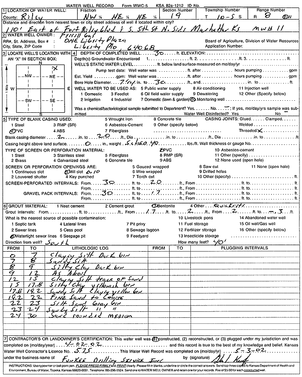
Specific Water Well Detail |
|
|
| Location Info | |||
| Owner: Ferrell Gas | Status: Constructed | ||
| Location: T10S, R8E, Sec. 19, NW NE NE | County: Riley | ||
| Directions: from Fort Riley Blvd and S 5th St, Manhattan: 110' E, N side | |||
| Latitude: 39.1734332 | Longitude: -96.5627915 | Datum NAD 27 | |
| Latitude: 39.1734305 | Longitude: -96.5630718 | Datum NAD 83 | |
| Longitude and latitude calculated by Survey from township-range-section-quarter calls. Only good to within the quarter call accuracy. | |||
| View well on interactive map | |||
| General Info | ||
| Well Depth: 30 ft. | Elevation: ft. | |
| Static Water Level: ft. | Est. Yield: gpm. | |
| Comp. Date: 02-Apr-2002 | Well Use: Monitoring well/observation/piezometer | |
| DWR Applic. #: | Other ID: MW 11 | |
| Driller Info | ||
| Driller: Funkee Drilling Service | License #: 575 | |
| Scanned Form | View scan |
|
Chemical Sample Submitted?:
Water Well disinfected?: | ||
| Casing Info | ||
| Casing Type:
Casing Joints: |
Diam: in. to ft | |
| Casing height above land surface: in
Casing Weight: lbs/ft Wall thickness or gauge no.: | ||
| Screen and Perforation Info | ||
| Screen Type: | Screen Openings: | |
| Screen-perforated intervals | From: ft to ft | |
| Gravel pack intervals | From: ft to ft | |
| Grout Info | ||
| Grout used: | From: to ft | |
| Source of Possible Contamination | ||
| Source: | ||
| Direction from well: | Distance: ft | |
| Lithologic Log
(Log data entered by KGS.) | ||
| From: 0 ft. to 7 ft. | Clayey silt, dark brown | |
| From: 7 ft. to 8 ft. | Sandy silt | |
| From: 8 ft. to 9 ft. | Silty clay, dark brown | |
| From: 9 ft. to 12 ft. | Silty clay, dark brown | |
| From: 12 ft. to 15 ft. | Clayey silt, trace of sand | |
| From: 15 ft. to 17.8 ft. | Silty clay, yellowish-brown | |
| From: 17.8 ft. to 19.2 ft. | Sandy silt, clayey, yellow, brown | |
| From: 19.2 ft. to 22 ft. | Fine sand to coarse | |
| From: 22 ft. to 23 ft. | Silt, sand, gray, brown | |
| From: 23 ft. to 24 ft. | Sandy silt, gray, brown | |
| From: 24 ft. to 30 ft. | Sand, rounded, medium | |