|
|
|
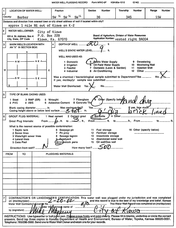
Specific Water Well Detail |
|
|
| Location Info | |||
| Owner: City of Kiowa | Status: Plugged | ||
| Location: T34S, R11W, Sec. 36, SW SW SW | County: Barber | ||
| Directions: from Kiowa: 1 mi NE on K-2 | |||
| Latitude: 37.036602 | Longitude: -98.4745418 | Datum NAD 27 | |
| Latitude: 37.0366286 | Longitude: -98.4748957 | Datum NAD 83 | |
| Longitude and latitude calculated by Survey from township-range-section-quarter calls. Only good to within the quarter call accuracy. | |||
| View well on interactive map | |||
| General Info | ||
| Well Depth: 20 ft. | Elevation: ft. | |
| Static Water Level: 9 ft. | Est. Yield: gpm. | |
| Comp. Date: 20-Feb-2002 | Well Use: Public Water Supply | |
| DWR Applic. #: BA004 | Other ID: | |
| Driller Info | ||
| Driller: City of Kiowa | License #: | |
| Scanned Form | View scan |
| Casing Info | ||
|
Casing Type:
Diam: in. Casing height above land surface: in | ||
| Grout Info | ||
| Grout used: | From: to ft | |
| Source of Possible Contamination | ||
| Source: | ||
| Direction from well: | Distance: ft | |