|
|
|
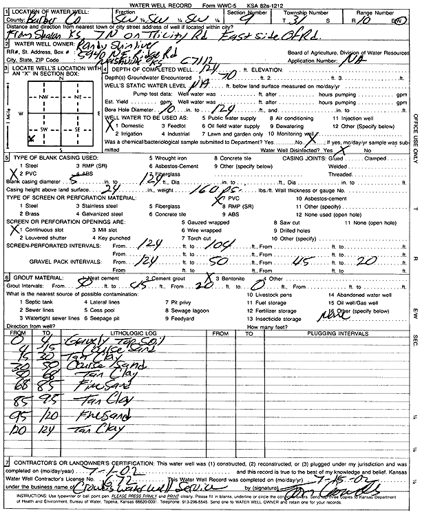
Specific Water Well Detail |
|
|
| Location Info | |||
| Owner: Shinliver, Randy | Status: Constructed | ||
| Location: T31S, R10W, Sec. 9, SW SW SW | County: Barber | ||
| Directions: from Sharon: 7 mi N on Tri-City Rd, E Side | |||
| Latitude: 37.3558859 | Longitude: -98.4210188 | Datum NAD 27 | |
| Latitude: 37.3559068 | Longitude: -98.4213734 | Datum NAD 83 | |
| Longitude and latitude calculated by Survey from township-range-section-quarter calls. Only good to within the quarter call accuracy. | |||
| View well on interactive map | |||
| General Info | ||
| Well Depth: 124 ft. | Elevation: ft. | |
| Static Water Level: ft. | Est. Yield: gpm. | |
| Comp. Date: 01-Jul-2002 | Well Use: Domestic | |
| DWR Applic. #: | Other ID: | |
| Driller Info | ||
| Driller: Crowdis Water Well Service, LLC | License #: 672 | |
| Scanned Form | View scan |
|
Chemical Sample Submitted?:
Water Well disinfected?: | ||
| Casing Info | ||
| Casing Type:
Casing Joints: |
Diam: in. to ft | |
| Casing height above land surface: in
Casing Weight: lbs/ft Wall thickness or gauge no.: | ||
| Screen and Perforation Info | ||
| Screen Type: | Screen Openings: | |
| Screen-perforated intervals | From: ft to ft | |
| Gravel pack intervals | From: ft to ft | |
| Grout Info | ||
| Grout used: | From: to ft | |
| Source of Possible Contamination | ||
| Source: | ||
| Direction from well: | Distance: ft | |
| Lithologic Log
(Log data entered by KGS.) | ||
| From: 0 ft. to 4 ft. | gravelly top soil | |
| From: 4 ft. to 15 ft. | coarse sand | |
| From: 15 ft. to 30 ft. | tan clay | |
| From: 30 ft. to 50 ft. | coarse sand | |
| From: 50 ft. to 68 ft. | tan clay | |
| From: 68 ft. to 85 ft. | fine sand | |
| From: 85 ft. to 95 ft. | tan clay | |
| From: 95 ft. to 120 ft. | fine sand | |
| From: 120 ft. to 124 ft. | tan clay | |