|
|
|
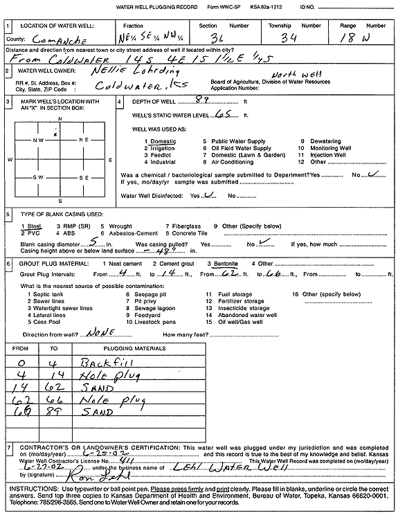
Specific Water Well Detail |
|
|
| Location Info | |||
| Owner: Lohrding, Nellie | Status: Plugged | ||
| Location: T34S, R18W, Sec. 36, NE SE NW | County: Comanche | ||
| Directions: from Coldwater: 14 mi S, 4 mi E, 1 mi S, 1.5 mi E, .25 mi S | |||
| Latitude: 37.0436268 | Longitude: -99.2259914 | Datum NAD 27 | |
| Latitude: 37.0436543 | Longitude: -99.2263786 | Datum NAD 83 | |
| Longitude and latitude calculated by Survey from township-range-section-quarter calls. Only good to within the quarter call accuracy. | |||
| View well on interactive map | |||
| General Info | ||
| Well Depth: 89 ft. | Elevation: ft. | |
| Static Water Level: 65 ft. | Est. Yield: gpm. | |
| Comp. Date: 25-Jun-2002 | Well Use: Domestic | |
| DWR Applic. #: | Other ID: North well | |
| Driller Info | ||
| Driller: Ronald Lehl's Water Well Service | License #: 411 | |
| Scanned Form | View scan |
| Casing Info | ||
|
Casing Type:
Diam: in. Casing height above land surface: in | ||
| Grout Info | ||
| Grout used: | From: to ft | |
| Source of Possible Contamination | ||
| Source: | ||
| Direction from well: | Distance: ft | |