|
|
|
Specific Water Well Detail |
|
|
| Location Info | |||
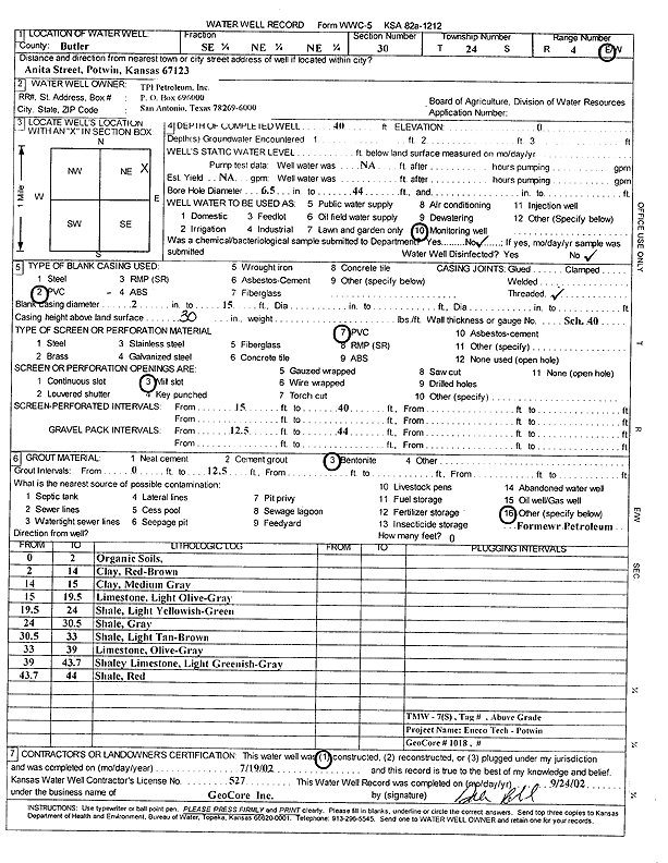
| Owner: TPI Petroleum, Inc. | Status: Constructed | ||
| Location: T24S, R4E, Sec. 30, SE NE NE | County: Butler | ||
| Directions: Anita St, Potwin | |||
| Latitude: 37.9385945 | Longitude: -97.0249952 | Datum NAD 27 | |
| Latitude: 37.9386118 | Longitude: -97.0253067 | Datum NAD 83 | |
| Longitude and latitude calculated by Survey from township-range-section-quarter calls. Only good to within the quarter call accuracy. | |||
| View well on interactive map | |||
| General Info | ||
| Well Depth: 40 ft. | Elevation: ft. | |
| Static Water Level: ft. | Est. Yield: gpm. | |
| Comp. Date: 19-Jul-2002 | Well Use: Monitoring well/observation/piezometer | |
| DWR Applic. #: | Other ID: TMW 7S | |
| Driller Info | ||
| Driller: GeoCore Services Inc. | License #: 527 | |
| Scanned Form | View scan |
|
Chemical Sample Submitted?:
Water Well disinfected?: | ||
| Casing Info | ||
| Casing Type:
Casing Joints: |
Diam: in. to ft | |
| Casing height above land surface: in
Casing Weight: lbs/ft Wall thickness or gauge no.: | ||
| Screen and Perforation Info | ||
| Screen Type: | Screen Openings: | |
| Screen-perforated intervals | From: ft to ft | |
| Gravel pack intervals | From: ft to ft | |
| Grout Info | ||
| Grout used: | From: to ft | |
| Source of Possible Contamination | ||
| Source: | ||
| Direction from well: | Distance: ft | |
| Lithologic Log
(Log data entered by KGS.) | ||
| From: 0 ft. to 2 ft. | organic soil | |
| From: 2 ft. to 14 ft. | clay, red brown | |
| From: 14 ft. to 15 ft. | clay, medium gray | |
| From: 15 ft. to 19.5 ft. | limestone, light olive gray | |
| From: 19.5 ft. to 24 ft. | shale, light yellowish green | |
| From: 24 ft. to 30.5 ft. | shale, gray | |
| From: 30.5 ft. to 33 ft. | shale, light tan brown | |
| From: 33 ft. to 39 ft. | limestone, olive gray | |
| From: 39 ft. to 43.7 ft. | shaley limestone, light greenish gray | |
| From: 43.7 ft. to 44 ft. | shale, red | |