|
|
|
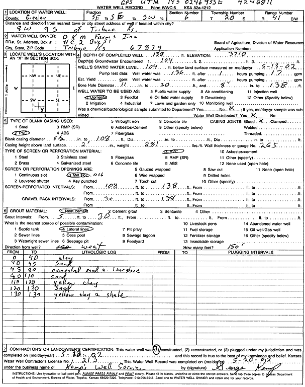
Specific Water Well Detail |
|
|
| Location Info | |||
| Owner: D K M Farms, Inc. | Status: Constructed | ||
| Location: T20S, R41W, Sec. 6, SE SE SW | County: Greeley | ||
| Directions: from Tribune: 8 mi W, 9 mi S | |||
| Latitude: 38.3358466 | Longitude: -101.8908828 | Datum NAD 27 | |
| Latitude: 38.3358627 | Longitude: -101.891337 | Datum NAD 83 | |
| Longitude and latitude calculated by Survey from township-range-section-quarter calls. Only good to within the quarter call accuracy. | |||
| View well on interactive map | |||
| General Info | ||
| Well Depth: 138 ft. | Elevation: 3710 ft. | |
| Static Water Level: 104 ft. | Est. Yield: gpm. | |
| Comp. Date: 13-May-2002 | Well Use: Domestic | |
| DWR Applic. #: | Other ID: | |
| Driller Info | ||
| Driller: George Kemp's Well Service | License #: 213 | |
| Scanned Form | View scan |
|
Chemical Sample Submitted?:
Water Well disinfected?: | ||
| Casing Info | ||
| Casing Type:
Casing Joints: |
Diam: in. to ft | |
| Casing height above land surface: in
Casing Weight: lbs/ft Wall thickness or gauge no.: | ||
| Screen and Perforation Info | ||
| Screen Type: | Screen Openings: | |
| Screen-perforated intervals | From: ft to ft | |
| Gravel pack intervals | From: ft to ft | |
| Grout Info | ||
| Grout used: | From: to ft | |
| Source of Possible Contamination | ||
| Source: | ||
| Direction from well: | Distance: ft | |
| Lithologic Log
(Log data entered by KGS.) | ||
| From: 0 ft. to 40 ft. | Clay | |
| From: 40 ft. to 45 ft. | Sand | |
| From: 45 ft. to 80 ft. | Cemented sand and limestone | |
| From: 80 ft. to 110 ft. | Sand | |
| From: 110 ft. to 120 ft. | Yellow clay | |
| From: 120 ft. to 130 ft. | Sand | |
| From: 130 ft. to 139 ft. | Yellow clay and shale | |