|
|
|
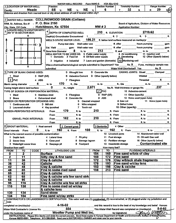
Specific Water Well Detail |
|
|
| Location Info | |||
| Owner: Collingwood Grain (Collano) | Status: Constructed | ||
| Location: T32S, R29W, Sec. 6, SE NE NE | County: Meade | ||
| Directions: | |||
| Latitude: 37.2975594 | Longitude: -100.508453 | Datum NAD 27 | |
| Latitude: 37.2975821 | Longitude: -100.5088814 | Datum NAD 83 | |
| Longitude and latitude calculated by Survey from township-range-section-quarter calls. Only good to within the quarter call accuracy. | |||
| View well on interactive map | |||
| General Info | ||
| Well Depth: 210 ft. | Elevation: 2719.62 ft. | |
| Static Water Level: 186.21 ft. | Est. Yield: gpm. | |
| Comp. Date: 16-Apr-2002 | Well Use: Monitoring well/observation/piezometer | |
| DWR Applic. #: | Other ID: MW 3 | |
| Driller Info | ||
| Driller: Jay C. Woofter Pump & Well, Inc. | License #: 554 | |
| Scanned Form | View scan |
|
Chemical Sample Submitted?:
Water Well disinfected?: | ||
| Casing Info | ||
| Casing Type:
Casing Joints: |
Diam: in. to ft | |
| Casing height above land surface: in
Casing Weight: lbs/ft Wall thickness or gauge no.: | ||
| Screen and Perforation Info | ||
| Screen Type: | Screen Openings: | |
| Screen-perforated intervals | From: ft to ft | |
| Gravel pack intervals | From: ft to ft | |
| Grout Info | ||
| Grout used: | From: to ft | |
| Source of Possible Contamination | ||
| Source: | ||
| Direction from well: | Distance: ft | |
| Lithologic Log
(Log data entered by KGS.) | ||
| From: 0 ft. to 2 ft. | surface | |
| From: 2 ft. to 11 ft. | silty clay and fine sand | |
| From: 11 ft. to 36 ft. | clay and caliche | |
| From: 36 ft. to 42 ft. | caliche | |
| From: 42 ft. to 48 ft. | clay and caliche | |
| From: 48 ft. to 55 ft. | fine to some medium sand | |
| From: 55 ft. to 62 ft. | clay and caliche | |
| From: 62 ft. to 68 ft. | clay and caliche with a few sand streaks | |
| From: 68 ft. to 95 ft. | clay and caliche | |
| From: 95 ft. to 116 ft. | clay and caliche with a few sand streaks | |
| From: 116 ft. to 130 ft. | fine to some medium sand with clay and caliche lens | |
| From: 130 ft. to 134 ft. | sandstone | |
| From: 134 ft. to 154 ft. | fine sand with clay streaks | |
| From: 154 ft. to 160 ft. | fine sand with lots of clay | |
| From: 160 ft. to 172 ft. | fine sand | |
| From: 172 ft. to 178 ft. | clay with black shale fragments | |
| From: 178 ft. to 193 ft. | fine sand with clay lens | |
| From: 193 ft. to 198 ft. | clay and caliche | |
| From: 198 ft. to 213 ft. | fine sand | |