|
|
|
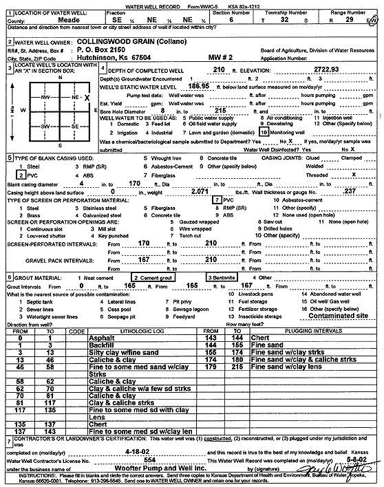
Specific Water Well Detail |
|
|
| Location Info | |||
| Owner: Collingwood Grain (Collano) | Status: Constructed | ||
| Location: T32S, R29W, Sec. 6, SE NE NE | County: Meade | ||
| Directions: | |||
| Latitude: 37.2975594 | Longitude: -100.508453 | Datum NAD 27 | |
| Latitude: 37.2975821 | Longitude: -100.5088814 | Datum NAD 83 | |
| Longitude and latitude calculated by Survey from township-range-section-quarter calls. Only good to within the quarter call accuracy. | |||
| View well on interactive map | |||
| General Info | ||
| Well Depth: 210 ft. | Elevation: 2722.93 ft. | |
| Static Water Level: 186.9 ft. | Est. Yield: gpm. | |
| Comp. Date: 18-Apr-2002 | Well Use: Monitoring well/observation/piezometer | |
| DWR Applic. #: | Other ID: MW 2 | |
| Driller Info | ||
| Driller: Jay C. Woofter Pump & Well, Inc. | License #: 554 | |
| Scanned Form | View scan |
|
Chemical Sample Submitted?:
Water Well disinfected?: | ||
| Casing Info | ||
| Casing Type:
Casing Joints: |
Diam: in. to ft | |
| Casing height above land surface: in
Casing Weight: lbs/ft Wall thickness or gauge no.: | ||
| Screen and Perforation Info | ||
| Screen Type: | Screen Openings: | |
| Screen-perforated intervals | From: ft to ft | |
| Gravel pack intervals | From: ft to ft | |
| Grout Info | ||
| Grout used: | From: to ft | |
| Source of Possible Contamination | ||
| Source: | ||
| Direction from well: | Distance: ft | |
| Lithologic Log
(Log data entered by KGS.) | ||
| From: 0 ft. to 1 ft. | asphalt | |
| From: 1 ft. to 3 ft. | backfill | |
| From: 3 ft. to 13 ft. | silty clay with fine sand | |
| From: 13 ft. to 46 ft. | caliche and clay | |
| From: 46 ft. to 58 ft. | fine to some medium sand with clay streaks | |
| From: 58 ft. to 62 ft. | caliche and clay | |
| From: 62 ft. to 70 ft. | clay and caliche with a few sand streaks | |
| From: 70 ft. to 81 ft. | caliche and clay | |
| From: 81 ft. to 117 ft. | clay and caliche streaks | |
| From: 117 ft. to 135 ft. | fine to some medium sand with clay lens | |
| From: 135 ft. to 137 ft. | chert | |
| From: 137 ft. to 143 ft. | fine to some medium sand with clay lens | |
| From: 143 ft. to 144 ft. | chert | |
| From: 144 ft. to 155 ft. | fine sand | |
| From: 155 ft. to 174 ft. | fine sand with clay streaks | |
| From: 174 ft. to 180 ft. | fine sand with clay and caliche streaks | |
| From: 180 ft. to 215 ft. | fine sand with clay lens | |