|
|
|
Specific Water Well Detail |
|
|
| Location Info | |||
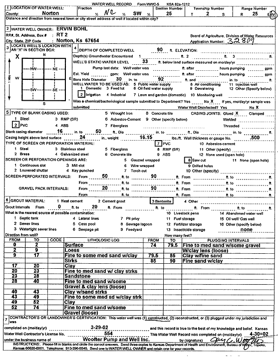
| Owner: Bohl, Ervin | Status: Constructed | ||
| Location: T2S, R25W, Sec. 25, NC SW | County: Norton | ||
| Directions: | |||
| Latitude: 39.8476812 | Longitude: -100.0904218 | Datum NAD 27 | |
| Latitude: 39.8476863 | Longitude: -100.0908314 | Datum NAD 83 | |
| Longitude and latitude calculated by Survey from township-range-section-quarter calls. Only good to within the quarter call accuracy. | |||
| View well on interactive map | |||
| General Info | ||
| Well Depth: 90 ft. | Elevation: ft. | |
| Static Water Level: 33 ft. | Est. Yield: gpm. | |
| Comp. Date: 29-Mar-2002 | Well Use: Irrigation | |
| DWR Applic. #: 32809 | Other ID: | |
| Links | |
| No Wizard information available. | |
| View info from WIMAS Water Right Data base... | |
| Driller Info | ||
| Driller: Jay C. Woofter Pump & Well, Inc. | License #: 554 | |
| Scanned Form | View scan |
|
Chemical Sample Submitted?:
Water Well disinfected?: | ||
| Casing Info | ||
| Casing Type:
Casing Joints: |
Diam: in. to ft | |
| Casing height above land surface: in
Casing Weight: lbs/ft Wall thickness or gauge no.: | ||
| Screen and Perforation Info | ||
| Screen Type: | Screen Openings: | |
| Screen-perforated intervals | From: ft to ft | |
| Gravel pack intervals | From: ft to ft | |
| Grout Info | ||
| Grout used: | From: to ft | |
| Source of Possible Contamination | ||
| Source: | ||
| Direction from well: | Distance: ft | |
| Lithologic Log
(Log data entered by KGS.) | ||
| From: 0 ft. to 2 ft. | surface | |
| From: 2 ft. to 9 ft. | loess | |
| From: 9 ft. to 17 ft. | fine to some medium sand with clay | |
| From: 17 ft. to 20 ft. | clay | |
| From: 20 ft. to 23 ft. | fine to medium sand with clay streak | |
| From: 23 ft. to 28 ft. | sandstone | |
| From: 28 ft. to 40 ft. | fine to medium sand with some gravel and clay lens (loose) | |
| From: 40 ft. to 43 ft. | clay with sand streak | |
| From: 43 ft. to 49 ft. | fine to some medium sand with clay streak | |
| From: 49 ft. to 52 ft. | clay | |
| From: 52 ft. to 74 ft. | fine to medium sand with some gravel (loose) | |
| From: 74 ft. to 79.5 ft. | fine to medium sand with some gravel with clay lens (loose) | |
| From: 79.5 ft. to 85 ft. | clay with fine sand | |
| From: 85 ft. to 90 ft. | fine sand with clay | |