|
|
|
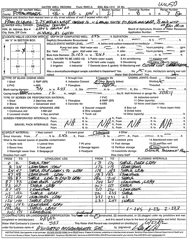
Specific Water Well Detail |
|
|
| Location Info | |||
| Owner: Duncan, Darin | Status: Constructed | ||
| Location: T8S, R7E, Sec. 21, SE NE NW | County: Pottawatomie | ||
| Directions: from Olsburg: 2.75 mi W on hwy 16, 6 mi S to Blue Mesa Rd, .5 mi W (1-245' bore, 1-230' bore, 2-223' bore) | |||
| Latitude: 39.3462062 | Longitude: -96.6544269 | Datum NAD 27 | |
| Latitude: 39.346203 | Longitude: -96.6547117 | Datum NAD 83 | |
| Longitude and latitude calculated by Survey from township-range-section-quarter calls. Only good to within the quarter call accuracy. | |||
| View well on interactive map | |||
| General Info | ||
| Well Depth: 245 ft. | Elevation: ft. | |
| Static Water Level: ft. | Est. Yield: gpm. | |
| Comp. Date: 15-Jun-2002 | Well Use: Heat Pump (Closed Loop/Disposal), Geothermal | |
| DWR Applic. #: | Other ID: WW 50 | |
| Driller Info | ||
| Driller: Associated Environmental, Inc. | License #: 585 | |
| Scanned Form | View scan |
|
Chemical Sample Submitted?:
Water Well disinfected?: | ||
| Casing Info | ||
| Casing Type:
Casing Joints: |
Diam: in. to ft | |
| Casing height above land surface: in
Casing Weight: lbs/ft Wall thickness or gauge no.: | ||
| Screen and Perforation Info | ||
| Screen Type: | Screen Openings: | |
| Screen-perforated intervals | From: ft to ft | |
| Gravel pack intervals | From: ft to ft | |
| Grout Info | ||
| Grout used: | From: to ft | |
| Source of Possible Contamination | ||
| Source: | ||
| Direction from well: | Distance: ft | |
| Lithologic Log
(Log data entered by KGS.) | ||
| From: 0 ft. to 2 ft. | shale, tan | |
| From: 2 ft. to 24 ft. | limestone, tan | |
| From: 24 ft. to 47 ft. | shale, red grades to gray | |
| From: 47 ft. to 48 ft. | limestone, gray | |
| From: 48 ft. to 87 ft. | shale, gray to red to gray | |
| From: 87 ft. to 95 ft. | limestone, gray | |
| From: 95 ft. to 117 ft. | shale, gray | |
| From: 117 ft. to 119 ft. | limestone | |
| From: 119 ft. to 122 ft. | shale, gray | |
| From: 122 ft. to 124 ft. | limestone, gray | |
| From: 124 ft. to 140 ft. | shale, red | |
| From: 140 ft. to 142 ft. | limestone, gray | |
| From: 142 ft. to 166 ft. | shale, gray | |
| From: 166 ft. to 171 ft. | limestone | |
| From: 171 ft. to 176 ft. | shale, dark gray | |
| From: 176 ft. to 178 ft. | limestone | |
| From: 178 ft. to 183 ft. | shale, gray | |
| From: 183 ft. to 185 ft. | limestone | |
| From: 185 ft. to 204 ft. | shale | |
| From: 204 ft. to 207 ft. | limestone, gray | |
| From: 207 ft. to 217 ft. | shale | |
| From: 217 ft. to 220 ft. | limestone | |
| From: 220 ft. to 233 ft. | shale | |
| From: 233 ft. to 235 ft. | limestone | |
| From: 235 ft. to 245 ft. | shale | |