|
|
|
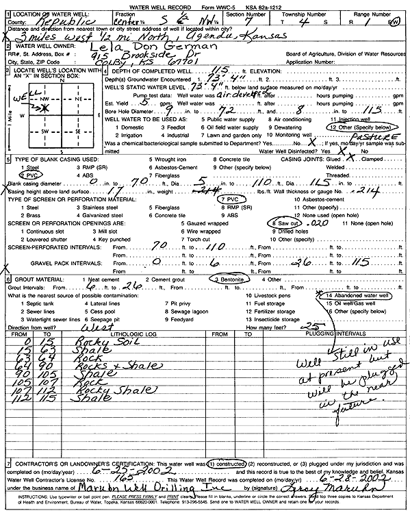
Specific Water Well Detail |
|
|
| Location Info | |||
| Owner: German, Lela Don | Status: Constructed | ||
| Location: T4S, R1W, Sec. 7, C S2 NW | County: Republic | ||
| Directions: from Agenda: 3 mi W and 0.5 mi N | |||
| Latitude: 39.7207299 | Longitude: -97.4760041 | Datum NAD 27 | |
| Latitude: 39.7207321 | Longitude: -97.4763201 | Datum NAD 83 | |
| Longitude and latitude calculated by Survey from township-range-section-quarter calls. Only good to within the quarter call accuracy. | |||
| View well on interactive map | |||
| General Info | ||
| Well Depth: 115 ft. | Elevation: ft. | |
| Static Water Level: 73.4 ft. | Est. Yield: 5 gpm. | |
| Comp. Date: 25-Jun-2002 | Well Use: Domestic, Livestock | |
| DWR Applic. #: | Other ID: | |
| Driller Info | ||
| Driller: Leroy Maruhn Well Drilling, Inc. | License #: 165 | |
| Scanned Form | View scan |
|
Chemical Sample Submitted?:
Water Well disinfected?: | ||
| Casing Info | ||
| Casing Type:
Casing Joints: |
Diam: in. to ft | |
| Casing height above land surface: in
Casing Weight: lbs/ft Wall thickness or gauge no.: | ||
| Screen and Perforation Info | ||
| Screen Type: | Screen Openings: | |
| Screen-perforated intervals | From: ft to ft | |
| Gravel pack intervals | From: ft to ft | |
| Grout Info | ||
| Grout used: | From: to ft | |
| Source of Possible Contamination | ||
| Source: | ||
| Direction from well: | Distance: ft | |
| Lithologic Log
(Log data entered by KGS.) | ||
| From: 0 ft. to 15 ft. | rocky soil | |
| From: 15 ft. to 63 ft. | shale | |
| From: 63 ft. to 64 ft. | rock | |
| From: 64 ft. to 90 ft. | rocks and shale | |
| From: 90 ft. to 105 ft. | shale | |
| From: 105 ft. to 107 ft. | rock | |
| From: 107 ft. to 112 ft. | rocky shale | |
| From: 112 ft. to 115 ft. | shale | |