|
|
|
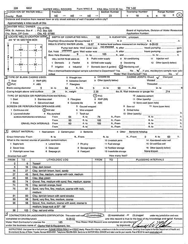
Specific Water Well Detail |
|
|
| Location Info | |||
| Owner: City of Otis | Status: Constructed | ||
| Location: T18S, R16W, Sec. 23, NE NE NE | County: Rush | ||
| Directions: from Otis: 4 mi S | |||
| Latitude: 38.4778603 | Longitude: -99.0522592 | Datum NAD 27 | |
| Latitude: 38.4778732 | Longitude: -99.0526328 | Datum NAD 83 | |
| Longitude and latitude calculated by Survey from township-range-section-quarter calls. Only good to within the quarter call accuracy. | |||
| View well on interactive map | |||
| General Info | ||
| Well Depth: 102 ft. | Elevation: ft. | |
| Static Water Level: 16.87 ft. | Est. Yield: gpm. | |
| Comp. Date: 26-Jun-2002 | Well Use: Monitoring well/observation/piezometer | |
| DWR Applic. #: | Other ID: TW 1-02 | |
| Driller Info | ||
| Driller: Clarke Well and Equipment, Inc. | License #: 185 | |
| Scanned Form | View scan |
|
Chemical Sample Submitted?:
Water Well disinfected?: | ||
| Casing Info | ||
| Casing Type:
Casing Joints: |
Diam: in. to ft | |
| Casing height above land surface: in
Casing Weight: lbs/ft Wall thickness or gauge no.: | ||
| Screen and Perforation Info | ||
| Screen Type: | Screen Openings: | |
| Screen-perforated intervals | From: ft to ft | |
| Gravel pack intervals | From: ft to ft | |
| Grout Info | ||
| Grout used: | From: to ft | |
| Source of Possible Contamination | ||
| Source: | ||
| Direction from well: | Distance: ft | |
| Lithologic Log
(Log data entered by KGS.) | ||
| From: 0 ft. to 6 ft. | topsoil | |
| From: 6 ft. to 16 ft. | clay, dark brown | |
| From: 16 ft. to 27 ft. | sandy clay, tannish brown, hard | |
| From: 27 ft. to 45 ft. | fine-medium-coarse sand with medium rock | |
| From: 45 ft. to 65 ft. | clay, blue green | |
| From: 65 ft. to 74 ft. | fine-medium gravel with fine-medium-coarse sand | |
| From: 74 ft. to 76 ft. | clay, tannish orange, hard | |
| From: 76 ft. to 81 ft. | very fine-fine-medium-coarse sand with medium rock | |
| From: 81 ft. to 89 ft. | clay, tannish brown, with sand streaks | |
| From: 89 ft. to 96 ft. | very fine-fine-medium-coarse sand | |
| From: 96 ft. to 98 ft. | fine-medium-coarse gravel with coarse to medium sand, large rock at 97 to 98 feet | |
| From: 98 ft. to 105 ft. | clay, red and white | |