|
|
|
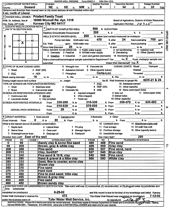
Specific Water Well Detail |
|
|
| Location Info | |||
| Owner: Priefert Family Trust | Status: Constructed | ||
| Location: T34S, R33W, Sec. 9, NE SE NW | County: Seward | ||
| Directions: from Liberal: 2 mi N | |||
| Latitude: 37.1078409 | Longitude: -100.9140443 | Datum NAD 27 | |
| Latitude: 37.1078656 | Longitude: -100.9144865 | Datum NAD 83 | |
| Longitude and latitude calculated by Survey from township-range-section-quarter calls. Only good to within the quarter call accuracy. | |||
| View well on interactive map | |||
| General Info | ||
| Well Depth: 590 ft. | Elevation: ft. | |
| Static Water Level: 260 ft. | Est. Yield: gpm. | |
| Comp. Date: 25-Jun-2002 | Well Use: Irrigation | |
| DWR Applic. #: 14715 | Other ID: | |
| Links | |
| No Wizard information available. | |
| View info from WIMAS Water Right Data base... | |
| Driller Info | ||
| Driller: Destal Tyler Water Well Service | License #: 473 | |
| Scanned Form | View scan |
|
Chemical Sample Submitted?:
Water Well disinfected?: | ||
| Casing Info | ||
| Casing Type:
Casing Joints: |
Diam: in. to ft | |
| Casing height above land surface: in
Casing Weight: lbs/ft Wall thickness or gauge no.: | ||
| Screen and Perforation Info | ||
| Screen Type: | Screen Openings: | |
| Screen-perforated intervals | From: ft to ft | |
| Gravel pack intervals | From: ft to ft | |
| Grout Info | ||
| Grout used: | From: to ft | |
| Source of Possible Contamination | ||
| Source: | ||
| Direction from well: | Distance: ft | |
| Lithologic Log
(Log data entered by KGS.) | ||
| From: 0 ft. to 60 ft. | sandy clay and some fine sand | |
| From: 60 ft. to 200 ft. | brown, gray and white clay | |
| From: 200 ft. to 208 ft. | fine sand | |
| From: 208 ft. to 213 ft. | clay, hard 527 | |
| From: 213 ft. to 240 ft. | fine sand and 10 ft clay | |
| From: 240 ft. to 280 ft. | sand and gravel and a little clay | |
| From: 280 ft. to 333 ft. | sand, fine to coarse; some clay | |
| From: 333 ft. to 350 ft. | brown clay | |
| From: 350 ft. to 370 ft. | fine sand | |
| From: 370 ft. to 375 ft. | hard rock | |
| From: 375 ft. to 405 ft. | fine to medium sand; little clay | |
| From: 405 ft. to 455 ft. | brown and gray clay | |
| From: 455 ft. to 468 ft. | fine sand | |
| From: 468 ft. to 480 ft. | brown sandy clay | |
| From: 480 ft. to 488 ft. | fine sand | |
| From: 488 ft. to 500 ft. | gray clay | |
| From: 500 ft. to 527 ft. | fine sand, hard | |
| From: 527 ft. to 540 ft. | blue clay | |
| From: 540 ft. to 566 ft. | fine sand | |
| From: 566 ft. to 590 ft. | white clay | |