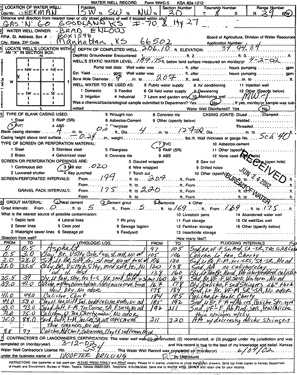
Lithologic Log
(Log data entered by KGS.) |
| |
From: 0 ft. to .5 ft. |
Asphalt |
| |
From: .5 ft. to 3 ft. |
Clay, brown, very silty, calc fragments, slightly moist, no odor |
| |
From: 3 ft. to 28 ft. |
Silt, light brown, soft, friable, slightly moist, no odor to slight odor |
| |
From: 28 ft. to 35.5 ft. |
Clay, brown, very silty to silty, medium soft, friable, no odor, slightly moist |
| |
From: 35.5 ft. to 39 ft. |
Clay, light tan, silty, trace fine-coarse s/r sand, no odor, stiff, very slightly moist |
| |
From: 39 ft. to 41 ft. |
Caliche, white tan, cemented calc. nodules and microcrystalline fragments, hard, dry, no odor |
| |
From: 41 ft. to 44 ft. |
Caliche, chert |
| |
From: 44 ft. to 53 ft. |
Clay, light tan, stiff, interbedded caliche rods, no odor |
| |
From: 53 ft. to 73 ft. |
Sand, buff, fine-medium, trace coarse, SA, poorly sorted, no odor |
| |
From: 73 ft. to 75 ft. |
Caliche, light tan, cherty, calcareous, no odor |
| |
From: 75 ft. to 88 ft. |
Sand, buff, fine-medium, trace coarse sand, white clay and caliche thin stringers, no odor |
| |
From: 88 ft. to 97 ft. |
Caliche, hard chert, calcareous, clay and fine sand lenses, no odor |
| |
From: 97 ft. to 105 ft. |
Sand, brown, very fine-fine, small medium, SA-SR, trace to abundant cobbles (greater than 3-inch diameter) |
| |
From: 105 ft. to 106 ft. |
Caliche, light tan, cherty |
| |
From: 106 ft. to 120 ft. |
Sand, light brown, fine-medium, trace coarse, SA-SR, no odor |
| |
From: 120 ft. to 138 ft. |
Sand, light brown, fine-medium, no caliche/clay |
| |
From: 138 ft. to 160 ft. |
Clay, light tan brown, hard, abundant interbedded caliche |
| |
From: 160 ft. to 167 ft. |
Sand, brown, very fine-fine, well sorted, uniform, no odor |
| |
From: 167 ft. to 178 ft. |
Clay/caliche, fine sand stringers less than 6-inches thick |
| |
From: 178 ft. to 184 ft. |
Sand, light brown, very fine-medium, SR-SA, no odor |
| |
From: 184 ft. to 185 ft. |
Caliche, light tan brown, cherty |
| |
From: 185 ft. to 192 ft. |
Sand, light brown, fine-medium with abundant coarse, caliche stringers |
| |
From: 192 ft. to 211 ft. |
Sand, very fine-fine, abundant medium, SAR, few caliche thin stringers with clay |
| |
From: 211 ft. to 220 ft. |
very fine-fine sand with decreasing caliche stringers |