|
|
|
Specific Water Well Detail |
|
|
| Location Info | |||
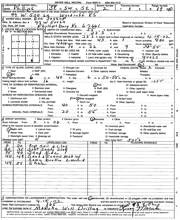
| Owner: Jessup, Don | Status: Constructed | ||
| Location: T1S, R19W, Sec. 2, SE SW SE | County: Phillips | ||
| Directions: 97 W 500 Ln, Phillipsburg | |||
| Latitude: 39.988366 | Longitude: -99.4276551 | Datum NAD 27 | |
| Latitude: 39.9883763 | Longitude: -99.4280336 | Datum NAD 83 | |
| Longitude and latitude calculated by Survey from township-range-section-quarter calls. Only good to within the quarter call accuracy. | |||
| View well on interactive map | |||
| General Info | ||
| Well Depth: 55 ft. | Elevation: ft. | |
| Static Water Level: 23.25 ft. | Est. Yield: 400 gpm. | |
| Comp. Date: 15-Apr-2002 | Well Use: Domestic, Lawn and Garden | |
| DWR Applic. #: | Other ID: | |
| Driller Info | ||
| Driller: Leroy Maruhn Well Drilling, Inc. | License #: 165 | |
| Scanned Form | View scan |
|
Chemical Sample Submitted?:
Water Well disinfected?: | ||
| Casing Info | ||
| Casing Type:
Casing Joints: |
Diam: in. to ft | |
| Casing height above land surface: in
Casing Weight: lbs/ft Wall thickness or gauge no.: | ||
| Screen and Perforation Info | ||
| Screen Type: | Screen Openings: | |
| Screen-perforated intervals | From: ft to ft | |
| Gravel pack intervals | From: ft to ft | |
| Grout Info | ||
| Grout used: | From: to ft | |
| Source of Possible Contamination | ||
| Source: | ||
| Direction from well: | Distance: ft | |
| Lithologic Log
(Log data entered by KGS.) | ||
| From: 0 ft. to 20 ft. | topsoil and clay | |
| From: 20 ft. to 35 ft. | soft sandy clay | |
| From: 35 ft. to 40 ft. | sand fine | |
| From: 40 ft. to 49 ft. | sand and gravel medium with some broken limerock | |
| From: 49 ft. to 55 ft. | shale | |