|
|
|
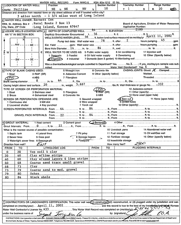
Specific Water Well Detail |
|
|
| Location Info | |||
| Owner: Cox, Barnett | Status: Constructed | ||
| Location: T1S, R20W, Sec. 10, NE NE NW | County: Phillips | ||
| Directions: from Long Island: 1.75 mi W, 3 mi N | |||
| Latitude: 39.9865585 | Longitude: -99.5614671 | Datum NAD 27 | |
| Latitude: 39.9865677 | Longitude: -99.5618517 | Datum NAD 83 | |
| Longitude and latitude calculated by Survey from township-range-section-quarter calls. Only good to within the quarter call accuracy. | |||
| View well on interactive map | |||
| General Info | ||
| Well Depth: 84 ft. | Elevation: 2180 ft. | |
| Static Water Level: 56 ft. | Est. Yield: gpm. | |
| Comp. Date: 11-Apr-2002 | Well Use: Irrigation | |
| DWR Applic. #: | Other ID: | |
| Links | |
| No Wizard information available. | |
| View info from WIMAS Water Right Data base... | |
| Driller Info | ||
| Driller: Chas. Sargent Irrigation Co., Inc. | License #: 433 | |
| Scanned Form | View scan |
|
Chemical Sample Submitted?:
Water Well disinfected?: | ||
| Casing Info | ||
| Casing Type:
Casing Joints: |
Diam: in. to ft | |
| Casing height above land surface: in
Casing Weight: lbs/ft Wall thickness or gauge no.: | ||
| Screen and Perforation Info | ||
| Screen Type: | Screen Openings: | |
| Screen-perforated intervals | From: ft to ft | |
| Gravel pack intervals | From: ft to ft | |
| Grout Info | ||
| Grout used: | From: to ft | |
| Source of Possible Contamination | ||
| Source: | ||
| Direction from well: | Distance: ft | |
| Lithologic Log
(Log data entered by KGS.) | ||
| From: 0 ft. to 20 ft. | topsoil and clay | |
| From: 20 ft. to 40 ft. | clay with lime strips | |
| From: 40 ft. to 60 ft. | clay with sand layers and lime strips | |
| From: 60 ft. to 68 ft. | coarse sand trace small gravel | |
| From: 68 ft. to 73 ft. | clay | |
| From: 73 ft. to 79 ft. | coarse sand to medium gravel | |
| From: 79 ft. to 80 ft. | ochre | |
| From: 80 ft. to 84 ft. | black shale | |