|
|
|
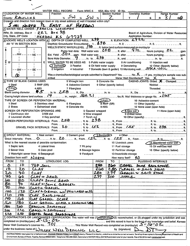
Specific Water Well Detail |
|
|
| Location Info | |||
| Owner: Wahrman, Francis | Status: Constructed | ||
| Location: T1S, R31W, Sec. 2, SW SW | County: Rawlins | ||
| Directions: from Herdon: 5 mi N, .5 mi E | |||
| Latitude: 39.9894187 | Longitude: -100.7732556 | Datum NAD 27 | |
| Latitude: 39.9894224 | Longitude: -100.7736867 | Datum NAD 83 | |
| Longitude and latitude calculated by Survey from township-range-section-quarter calls. Only good to within the quarter call accuracy. | |||
| View well on interactive map | |||
| General Info | ||
| Well Depth: 298 ft. | Elevation: 2922 ft. | |
| Static Water Level: 198 ft. | Est. Yield: 50 gpm. | |
| Comp. Date: 15-May-2002 | Well Use: Domestic | |
| DWR Applic. #: | Other ID: | |
| Driller Info | ||
| Driller: Wilcox Well Drilling, LLC | License #: 701 | |
| Scanned Form | View scan |
|
Chemical Sample Submitted?:
Water Well disinfected?: | ||
| Casing Info | ||
| Casing Type:
Casing Joints: |
Diam: in. to ft | |
| Casing height above land surface: in
Casing Weight: lbs/ft Wall thickness or gauge no.: | ||
| Screen and Perforation Info | ||
| Screen Type: | Screen Openings: | |
| Screen-perforated intervals | From: ft to ft | |
| Gravel pack intervals | From: ft to ft | |
| Grout Info | ||
| Grout used: | From: to ft | |
| Source of Possible Contamination | ||
| Source: | ||
| Direction from well: | Distance: ft | |
| Lithologic Log
(Log data entered by KGS.) | ||
| From: 0 ft. to 10 ft. | top soil | |
| From: 10 ft. to 20 ft. | clay | |
| From: 20 ft. to 40 ft. | clay | |
| From: 40 ft. to 60 ft. | clay and sand | |
| From: 60 ft. to 80 ft. | clay and some sand | |
| From: 80 ft. to 90 ft. | clay and some gravel | |
| From: 90 ft. to 100 ft. | clay and gravel | |
| From: 100 ft. to 120 ft. | clay and gravel with thin layers of sandstone | |
| From: 120 ft. to 140 ft. | clay, sandstone | |
| From: 140 ft. to 160 ft. | clay, gravel, ochre | |
| From: 160 ft. to 180 ft. | clay, gravel, ochre, and sandstone layers | |
| From: 180 ft. to 200 ft. | gravel and sandstone | |
| From: 200 ft. to 220 ft. | gravel and sandstone | |
| From: 220 ft. to 240 ft. | gravel, some sandstone | |
| From: 240 ft. to 260 ft. | gravel, some sandstone | |
| From: 260 ft. to 280 ft. | gravel and sandstone | |
| From: 280 ft. to 297 ft. | gravel and sandstone | |
| From: 297 ft. to 300 ft. | shale | |