|
|
|
Specific Water Well Detail |
|
|
| Location Info | |||
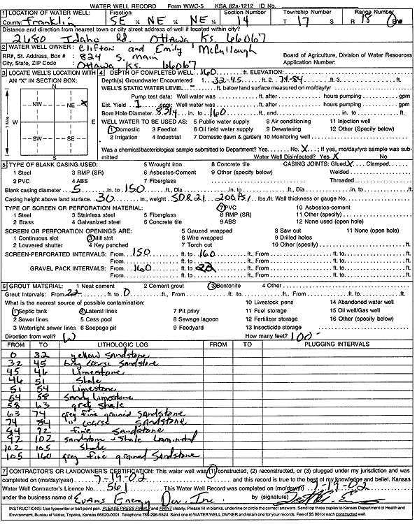
| Owner: McCullough, Clifton and Emily | Status: Constructed | ||
| Location: T17S, R18E, Sec. 14, SE NE NE | County: Franklin | ||
| Directions: 2680 Idaho Rd, Ottawa | |||
| Latitude: 38.5764963 | Longitude: -95.3794996 | Datum NAD 27 | |
| Latitude: 38.5765081 | Longitude: -95.3797545 | Datum NAD 83 | |
| Longitude and latitude calculated by Survey from township-range-section-quarter calls. Only good to within the quarter call accuracy. | |||
| View well on interactive map | |||
| General Info | ||
| Well Depth: 160 ft. | Elevation: ft. | |
| Static Water Level: ft. | Est. Yield: 1 gpm. | |
| Comp. Date: 19-Jul-2002 | Well Use: Domestic | |
| DWR Applic. #: | Other ID: | |
| Driller Info | ||
| Driller: Evans Energy Development, Inc. | License #: 561 | |
| Scanned Form | View scan |
|
Chemical Sample Submitted?:
Water Well disinfected?: | ||
| Casing Info | ||
| Casing Type:
Casing Joints: |
Diam: in. to ft | |
| Casing height above land surface: in
Casing Weight: lbs/ft Wall thickness or gauge no.: | ||
| Screen and Perforation Info | ||
| Screen Type: | Screen Openings: | |
| Screen-perforated intervals | From: ft to ft | |
| Gravel pack intervals | From: ft to ft | |
| Grout Info | ||
| Grout used: | From: to ft | |
| Source of Possible Contamination | ||
| Source: | ||
| Direction from well: | Distance: ft | |
| Lithologic Log
(Log data entered by KGS.) | ||
| From: 0 ft. to 32 ft. | Sandstone, yellow | |
| From: 32 ft. to 45 ft. | Coarse sandstone, gray | |
| From: 45 ft. to 46 ft. | Limestone | |
| From: 46 ft. to 51 ft. | Shale | |
| From: 51 ft. to 54 ft. | Limestone | |
| From: 54 ft. to 58 ft. | Sandy limestone | |
| From: 58 ft. to 63 ft. | Shale, gray | |
| From: 63 ft. to 74 ft. | Fine-grained sandstone, gray | |
| From: 74 ft. to 84 ft. | Coarse sandstone, gray | |
| From: 84 ft. to 92 ft. | Fine-grained sandstone | |
| From: 92 ft. to 102 ft. | Sandstone and shale, laminated | |
| From: 102 ft. to 105 ft. | Shale | |
| From: 105 ft. to 160 ft. | Fine-grained sandstone, gray | |