|
|
|
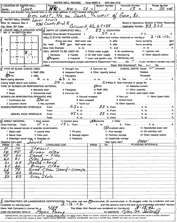
Specific Water Well Detail |
|
|
| Location Info | |||
| Owner: Lewis, Larri | Status: Constructed | ||
| Location: T13S, R30W, Sec. 1, NW NW SE | County: Gove | ||
| Directions: from Gove: 6 mi W, .75 mi S, .5 mi W | |||
| Latitude: 38.9522124 | Longitude: -100.6007375 | Datum NAD 27 | |
| Latitude: 38.9522227 | Longitude: -100.6011552 | Datum NAD 83 | |
| Longitude and latitude calculated by Survey from township-range-section-quarter calls. Only good to within the quarter call accuracy. | |||
| View well on interactive map | |||
| General Info | ||
| Well Depth: 83 ft. | Elevation: ft. | |
| Static Water Level: 50 ft. | Est. Yield: 60 gpm. | |
| Comp. Date: 16-Feb-2002 | Well Use: Irrigation | |
| DWR Applic. #: 43,325 | Other ID: | |
| Links | |
| No Wizard information available. | |
| View info from WIMAS Water Right Data base... | |
| Driller Info | ||
| Driller: Aqua Pump | License #: 489 | |
| Scanned Form | View scan |
|
Chemical Sample Submitted?:
Water Well disinfected?: | ||
| Casing Info | ||
| Casing Type:
Casing Joints: |
Diam: in. to ft | |
| Casing height above land surface: in
Casing Weight: lbs/ft Wall thickness or gauge no.: | ||
| Screen and Perforation Info | ||
| Screen Type: | Screen Openings: | |
| Screen-perforated intervals | From: ft to ft | |
| Gravel pack intervals | From: ft to ft | |
| Grout Info | ||
| Grout used: | From: to ft | |
| Source of Possible Contamination | ||
| Source: | ||
| Direction from well: | Distance: ft | |
| Lithologic Log
(Log data entered by KGS.) | ||
| From: 0 ft. to 10 ft. | Topsoil | |
| From: 10 ft. to 45 ft. | Brown clay | |
| From: 45 ft. to 60 ft. | Sand, fine | |
| From: 60 ft. to 61 ft. | Clay layer | |
| From: 61 ft. to 64 ft. | Sand, medium | |
| From: 64 ft. to 66 ft. | Brown clay | |
| From: 66 ft. to 78 ft. | Good clean sand, coarse | |
| From: 78 ft. to 82 ft. | Gravel | |
| From: 82 ft. to 83 ft. | Gray shale | |