|
|
|
Specific Water Well Detail |
|
|
| Location Info | |||
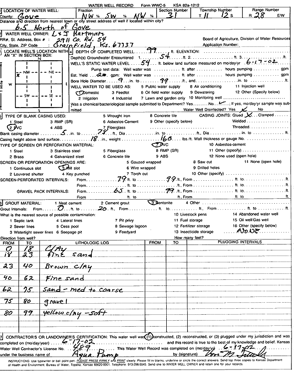
| Owner: L and J Hartman Corp. | Status: Constructed | ||
| Location: T11S, R28W, Sec. 31, NW SW NW | County: Gove | ||
| Directions: from Gove: 6.5 mi N | |||
| Latitude: 39.0562483 | Longitude: -100.4796383 | Datum NAD 27 | |
| Latitude: 39.0562566 | Longitude: -100.4800544 | Datum NAD 83 | |
| Longitude and latitude calculated by Survey from township-range-section-quarter calls. Only good to within the quarter call accuracy. | |||
| View well on interactive map | |||
| General Info | ||
| Well Depth: 99 ft. | Elevation: ft. | |
| Static Water Level: 54 ft. | Est. Yield: 20 gpm. | |
| Comp. Date: 17-Jun-2002 | Well Use: Domestic | |
| DWR Applic. #: | Other ID: | |
| Driller Info | ||
| Driller: Aqua Pump LLC | License #: 489 | |
| Scanned Form | View scan |
|
Chemical Sample Submitted?:
Water Well disinfected?: | ||
| Casing Info | ||
| Casing Type:
Casing Joints: |
Diam: in. to ft | |
| Casing height above land surface: in
Casing Weight: lbs/ft Wall thickness or gauge no.: | ||
| Screen and Perforation Info | ||
| Screen Type: | Screen Openings: | |
| Screen-perforated intervals | From: ft to ft | |
| Gravel pack intervals | From: ft to ft | |
| Grout Info | ||
| Grout used: | From: to ft | |
| Source of Possible Contamination | ||
| Source: | ||
| Direction from well: | Distance: ft | |
| Lithologic Log
(Log data entered by KGS.) | ||
| From: 0 ft. to 18 ft. | Clay | |
| From: 18 ft. to 23 ft. | Fine sand | |
| From: 23 ft. to 40 ft. | Brown clay | |
| From: 40 ft. to 62 ft. | Fine sand | |
| From: 62 ft. to 75 ft. | Sand, medium to coarse | |
| From: 75 ft. to 80 ft. | Gravel | |
| From: 80 ft. to 99 ft. | Yellow clay, soft | |