|
|
|
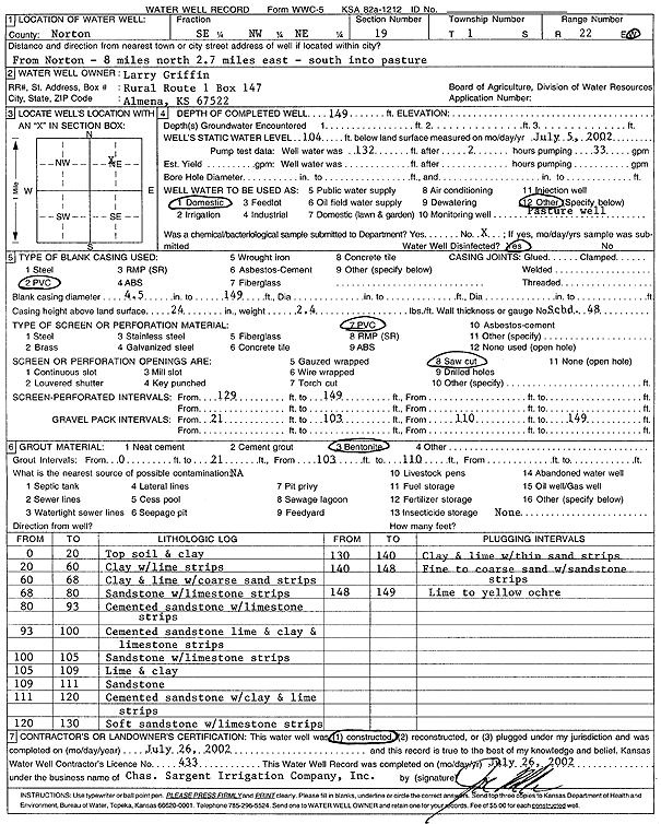
Specific Water Well Detail |
|
|
| Location Info | |||
| Owner: Griffin, Larry | Status: Constructed | ||
| Location: T1S, R22W, Sec. 19, SE NW NE | County: Norton | ||
| Directions: from Norton: 8 mi N, 2.7 mi E, S into pasture | |||
| Latitude: 39.9552975 | Longitude: -99.8376538 | Datum NAD 27 | |
| Latitude: 39.9553042 | Longitude: -99.8380515 | Datum NAD 83 | |
| Longitude and latitude calculated by Survey from township-range-section-quarter calls. Only good to within the quarter call accuracy. | |||
| View well on interactive map | |||
| General Info | ||
| Well Depth: 149 ft. | Elevation: ft. | |
| Static Water Level: 104 ft. | Est. Yield: gpm. | |
| Comp. Date: 26-Jul-2002 | Well Use: Domestic | |
| DWR Applic. #: | Other ID: | |
| Driller Info | ||
| Driller: Chas. Sargent Irrigation Co., Inc. | License #: 433 | |
| Scanned Form | View scan |
|
Chemical Sample Submitted?:
Water Well disinfected?: | ||
| Casing Info | ||
| Casing Type:
Casing Joints: |
Diam: in. to ft | |
| Casing height above land surface: in
Casing Weight: lbs/ft Wall thickness or gauge no.: | ||
| Screen and Perforation Info | ||
| Screen Type: | Screen Openings: | |
| Screen-perforated intervals | From: ft to ft | |
| Gravel pack intervals | From: ft to ft | |
| Grout Info | ||
| Grout used: | From: to ft | |
| Source of Possible Contamination | ||
| Source: | ||
| Direction from well: | Distance: ft | |
| Lithologic Log
(Log data entered by KGS.) | ||
| From: 0 ft. to 20 ft. | topsoil and clay | |
| From: 20 ft. to 60 ft. | clay with lime strips | |
| From: 60 ft. to 68 ft. | clay and lime with coarse sand strips | |
| From: 68 ft. to 80 ft. | sandstone with limestone strips | |
| From: 80 ft. to 93 ft. | cemented sandstone with limestone strips | |
| From: 93 ft. to 100 ft. | cemented sandstone lime and clay and limestone strips | |
| From: 100 ft. to 105 ft. | sandstone with limestone strips | |
| From: 105 ft. to 109 ft. | lime and clay | |
| From: 109 ft. to 111 ft. | sandstone | |
| From: 111 ft. to 120 ft. | cemented sandstone with clay and lime strips | |
| From: 120 ft. to 130 ft. | soft sandstone with limestone strips | |
| From: 130 ft. to 140 ft. | clay and lime with thin sand strips | |
| From: 140 ft. to 148 ft. | fine to coarse sand with sandstone strips | |
| From: 148 ft. to 149 ft. | lime to yellow ochre | |