|
|
|
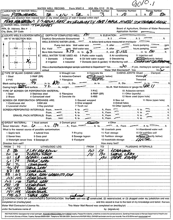
Specific Water Well Detail |
|
|
| Location Info | |||
| Owner: Ekart, Tim | Status: Constructed | ||
| Location: T10S, R8E, Sec. 3, SE NW SE | County: Pottawatomie | ||
| Directions: from Manhattan: 2.5 mi E on Hwy 24, 1 mi N, Timber Creek | |||
| Latitude: 39.208379 | Longitude: -96.5067961 | Datum NAD 27 | |
| Latitude: 39.208376 | Longitude: -96.5070751 | Datum NAD 83 | |
| Longitude and latitude calculated by Survey from township-range-section-quarter calls. Only good to within the quarter call accuracy. | |||
| View well on interactive map | |||
| General Info | ||
| Well Depth: 190 ft. | Elevation: ft. | |
| Static Water Level: ft. | Est. Yield: gpm. | |
| Comp. Date: 01-Jun-2002 | Well Use: Heat Pump (Closed Loop/Disposal), Geothermal | |
| DWR Applic. #: | Other ID: GO 10.1 | |
| Driller Info | ||
| Driller: Associated Environmental, Inc. | License #: 585 | |
| Scanned Form | View scan |
|
Chemical Sample Submitted?:
Water Well disinfected?: | ||
| Casing Info | ||
| Casing Type:
Casing Joints: |
Diam: in. to ft | |
| Casing height above land surface: in
Casing Weight: lbs/ft Wall thickness or gauge no.: | ||
| Screen and Perforation Info | ||
| Screen Type: | Screen Openings: | |
| Screen-perforated intervals | From: ft to ft | |
| Gravel pack intervals | From: ft to ft | |
| Grout Info | ||
| Grout used: | From: to ft | |
| Source of Possible Contamination | ||
| Source: | ||
| Direction from well: | Distance: ft | |
| Lithologic Log
(Log data entered by KGS.) | ||
| From: 0 ft. to 20 ft. | clay, red brown | |
| From: 20 ft. to 41 ft. | clayey sand | |
| From: 41 ft. to 61 ft. | coarse gravel | |
| From: 61 ft. to 74 ft. | shale, gray | |
| From: 74 ft. to 76 ft. | limestone | |
| From: 76 ft. to 84 ft. | shale, gray | |
| From: 84 ft. to 88 ft. | limestone | |
| From: 88 ft. to 103 ft. | shale, gray grades to red | |
| From: 103 ft. to 105 ft. | limestone | |
| From: 105 ft. to 140 ft. | shale, gray | |
| From: 140 ft. to 141 ft. | limestone | |
| From: 141 ft. to 147 ft. | shale, gray | |
| From: 147 ft. to 148 ft. | limestone | |
| From: 148 ft. to 167 ft. | shale, gray | |
| From: 167 ft. to 171 ft. | limestone | |
| From: 171 ft. to 190 ft. | shale, gray | |