|
|
|
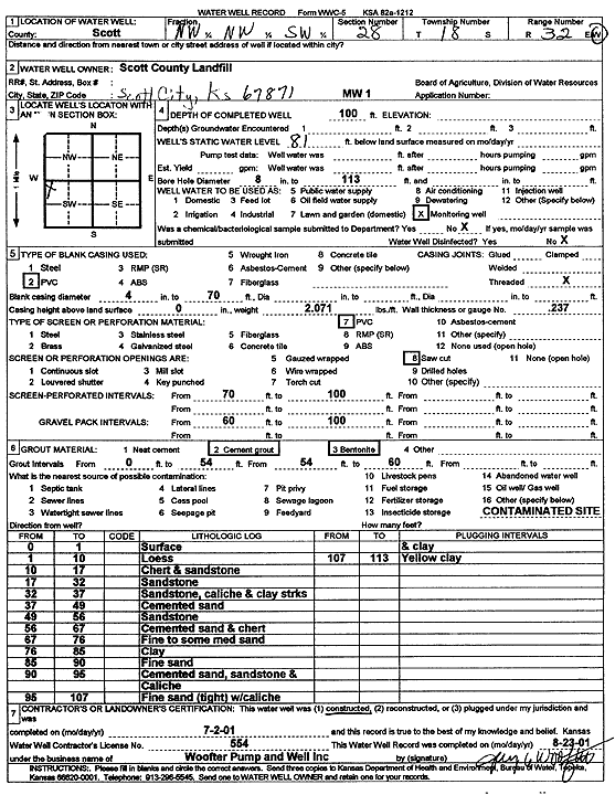
Specific Water Well Detail |
|
|
| Location Info | |||
| Owner: Scott County Landfill | Status: Constructed | ||
| Location: T18S, R32W, Sec. 28, NW NW SW | County: Scott | ||
| Directions: | |||
| Latitude: 38.4599497 | Longitude: -100.8683833 | Datum NAD 27 | |
| Latitude: 38.4599689 | Longitude: -100.8688116 | Datum NAD 83 | |
| Longitude and latitude calculated by Survey from township-range-section-quarter calls. Only good to within the quarter call accuracy. | |||
| View well on interactive map | |||
| General Info | ||
| Well Depth: 100 ft. | Elevation: ft. | |
| Static Water Level: 81 ft. | Est. Yield: gpm. | |
| Comp. Date: 02-Jul-2001 | Well Use: Monitoring well/observation/piezometer | |
| DWR Applic. #: | Other ID: MW 1 | |
| Driller Info | ||
| Driller: Jay C. Woofter Pump & Well, Inc. | License #: 554 | |
| Scanned Form | View scan |
|
Chemical Sample Submitted?:
Water Well disinfected?: | ||
| Casing Info | ||
| Casing Type:
Casing Joints: |
Diam: in. to ft | |
| Casing height above land surface: in
Casing Weight: lbs/ft Wall thickness or gauge no.: | ||
| Screen and Perforation Info | ||
| Screen Type: | Screen Openings: | |
| Screen-perforated intervals | From: ft to ft | |
| Gravel pack intervals | From: ft to ft | |
| Grout Info | ||
| Grout used: | From: to ft | |
| Source of Possible Contamination | ||
| Source: | ||
| Direction from well: | Distance: ft | |
| Lithologic Log
(Log data entered by KGS.) | ||
| From: 0 ft. to 1 ft. | surface | |
| From: 1 ft. to 10 ft. | loess | |
| From: 10 ft. to 17 ft. | chert and sandstone | |
| From: 17 ft. to 32 ft. | sandstone | |
| From: 32 ft. to 37 ft. | sandstone, caliche and clay streaks | |
| From: 37 ft. to 49 ft. | cemented sand | |
| From: 49 ft. to 56 ft. | sandstone | |
| From: 56 ft. to 67 ft. | cemented sand and chert | |
| From: 67 ft. to 76 ft. | fine to some med sand | |
| From: 76 ft. to 85 ft. | clay | |
| From: 85 ft. to 90 ft. | fine sand | |
| From: 90 ft. to 95 ft. | cemented sand, sandstone and caliche | |
| From: 95 ft. to 107 ft. | fine sand (tight) with caliche and clay | |
| From: 107 ft. to 113 ft. | yellow clay | |