|
|
|
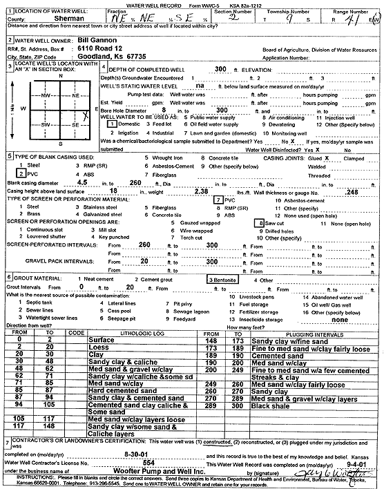
Specific Water Well Detail |
|
|
| Location Info | |||
| Owner: Gannon, Bill | Status: Constructed | ||
| Location: T9S, R41W, Sec. 2, NE NE SE | County: Sherman | ||
| Directions: | |||
| Latitude: 39.2990735 | Longitude: -101.8569601 | Datum NAD 27 | |
| Latitude: 39.2990737 | Longitude: -101.8574142 | Datum NAD 83 | |
| Longitude and latitude calculated by Survey from township-range-section-quarter calls. Only good to within the quarter call accuracy. | |||
| View well on interactive map | |||
| General Info | ||
| Well Depth: 300 ft. | Elevation: ft. | |
| Static Water Level: ft. | Est. Yield: gpm. | |
| Comp. Date: 30-Aug-2001 | Well Use: Domestic | |
| DWR Applic. #: | Other ID: | |
| Driller Info | ||
| Driller: Jay C. Woofter Pump & Well, Inc. | License #: 554 | |
| Scanned Form | View scan |
|
Chemical Sample Submitted?:
Water Well disinfected?: | ||
| Casing Info | ||
| Casing Type:
Casing Joints: |
Diam: in. to ft | |
| Casing height above land surface: in
Casing Weight: lbs/ft Wall thickness or gauge no.: | ||
| Screen and Perforation Info | ||
| Screen Type: | Screen Openings: | |
| Screen-perforated intervals | From: ft to ft | |
| Gravel pack intervals | From: ft to ft | |
| Grout Info | ||
| Grout used: | From: to ft | |
| Source of Possible Contamination | ||
| Source: | ||
| Direction from well: | Distance: ft | |
| Lithologic Log
(Log data entered by KGS.) | ||
| From: 0 ft. to 2 ft. | Surface | |
| From: 2 ft. to 20 ft. | Loess | |
| From: 20 ft. to 30 ft. | Clay | |
| From: 30 ft. to 48 ft. | Sandy clay and caliche | |
| From: 48 ft. to 62 ft. | Medium sand and gravel with clay | |
| From: 62 ft. to 71 ft. | Sandy clay with caliche and some sand | |
| From: 71 ft. to 85 ft. | Medium sand with clay | |
| From: 85 ft. to 87 ft. | Hard cemented sand | |
| From: 87 ft. to 94 ft. | Sandy clay and cemented sand | |
| From: 94 ft. to 105 ft. | Cemented sand, clay, caliche, and some sand | |
| From: 105 ft. to 117 ft. | Medium sand with clay layers, loose | |
| From: 117 ft. to 148 ft. | Sandy clay with some sand and caliche layers | |
| From: 148 ft. to 173 ft. | Sandy clay with fine sand | |
| From: 173 ft. to 189 ft. | Fine to medium sand with clay, fairly loose | |
| From: 189 ft. to 190 ft. | Cemented sand | |
| From: 190 ft. to 200 ft. | Medium sand with clay | |
| From: 200 ft. to 249 ft. | Fine to medium sand with a few cemented streaks and clay | |
| From: 249 ft. to 260 ft. | Medium sand with clay, fairly loose | |
| From: 260 ft. to 270 ft. | Sandy clay | |
| From: 270 ft. to 289 ft. | Medium sand and gravel with clay layers | |
| From: 289 ft. to 300 ft. | Black shale | |