|
|
|
Specific Water Well Detail |
|
|
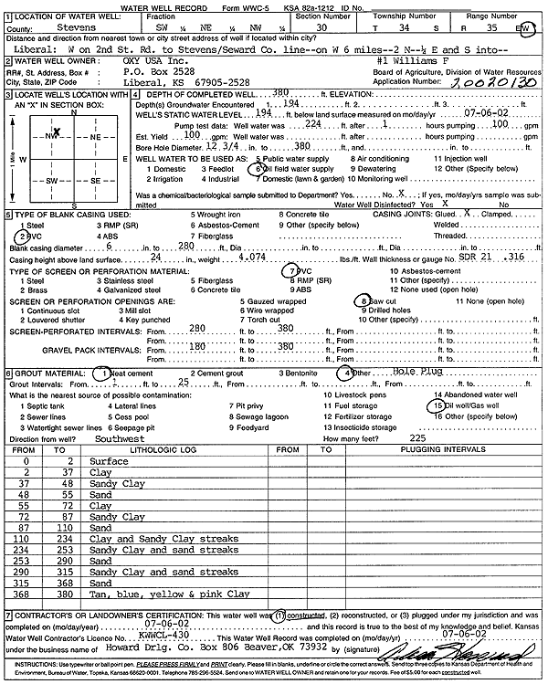
| Location Info | |||
| Owner: Oxy USA, Inc. | Status: Constructed | ||
| Location: T34S, R35W, Sec. 30, SW NE NW | County: Stevens | ||
| Directions: from Liberal: W on 2nd St to Stevens/Seward Co. line, 6 mi W, 2 mi N, .25 mi E and S into site | |||
| Latitude: 37.065889 | Longitude: -101.1694895 | Datum NAD 27 | |
| Latitude: 37.0659147 | Longitude: -101.1699304 | Datum NAD 83 | |
| Longitude and latitude calculated by Survey from township-range-section-quarter calls. Only good to within the quarter call accuracy. | |||
| View well on interactive map | |||
| General Info | ||
| Well Depth: 380 ft. | Elevation: ft. | |
| Static Water Level: 194 ft. | Est. Yield: 100 gpm. | |
| Comp. Date: 06-Jul-2002 | Well Use: Oil Field Water Supply | |
| DWR Applic. #: 20020130 | Other ID: Williams F-1 | |
| Links | |
| No Wizard information available. | |
| View info from WIMAS Water Right Data base... | |
| Driller Info | ||
| Driller: Howard Drilling Company AG, LLC | License #: 430 | |
| Scanned Form | View scan |
|
Chemical Sample Submitted?:
Water Well disinfected?: | ||
| Casing Info | ||
| Casing Type:
Casing Joints: |
Diam: in. to ft | |
| Casing height above land surface: in
Casing Weight: lbs/ft Wall thickness or gauge no.: | ||
| Screen and Perforation Info | ||
| Screen Type: | Screen Openings: | |
| Screen-perforated intervals | From: ft to ft | |
| Gravel pack intervals | From: ft to ft | |
| Grout Info | ||
| Grout used: | From: to ft | |
| Source of Possible Contamination | ||
| Source: | ||
| Direction from well: | Distance: ft | |
| Lithologic Log
(Log data entered by KGS.) | ||
| From: 0 ft. to 2 ft. | surface | |
| From: 2 ft. to 37 ft. | clay | |
| From: 37 ft. to 48 ft. | sandy clay | |
| From: 48 ft. to 55 ft. | sand | |
| From: 55 ft. to 72 ft. | clay | |
| From: 72 ft. to 87 ft. | sandy clay | |
| From: 87 ft. to 110 ft. | sand | |
| From: 110 ft. to 234 ft. | clay and sandy clay streaks | |
| From: 234 ft. to 253 ft. | sandy clay and sand streaks | |
| From: 253 ft. to 290 ft. | sand | |
| From: 290 ft. to 315 ft. | sandy clay and sand streaks | |
| From: 315 ft. to 368 ft. | sand | |
| From: 368 ft. to 380 ft. | tan, blue, yellow and pink clay | |