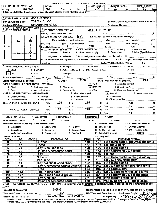
Lithologic Log
(Log data entered by KGS.) |
| |
From: 0 ft. to 2 ft. |
surface |
| |
From: 2 ft. to 17 ft. |
loess |
| |
From: 17 ft. to 70 ft. |
clay and caliche lens |
| |
From: 70 ft. to 76 ft. |
caliche and cemented sand |
| |
From: 76 ft. to 81 ft. |
clay |
| |
From: 81 ft. to 82 ft. |
caliche |
| |
From: 82 ft. to 86 ft. |
medium sand |
| |
From: 86 ft. to 91 ft. |
clay, caliche, and sand streaks |
| |
From: 91 ft. to 108 ft. |
clay and cemented sand and caliche streaks |
| |
From: 108 ft. to 114 ft. |
fine to medium sand |
| |
From: 114 ft. to 127 ft. |
fine to medium sand and gravel |
| |
From: 127 ft. to 132 ft. |
clay and caliche |
| |
From: 132 ft. to 142 ft. |
caliche and cemented sand |
| |
From: 142 ft. to 157 ft. |
fine to medium sand and gravel with caliche streaks |
| |
From: 157 ft. to 162 ft. |
caliche and chert |
| |
From: 162 ft. to 166 ft. |
fine to medium sand |
| |
From: 166 ft. to 173 ft. |
fine sand with clay and caliche |
| |
From: 173 ft. to 176 ft. |
caliche |
| |
From: 176 ft. to 182 ft. |
fine to medium sand and some gravel with clay |
| |
From: 182 ft. to 197 ft. |
clay with a few sand streaks |
| |
From: 197 ft. to 225 ft. |
fine to medium sand |
| |
From: 225 ft. to 234 ft. |
clay and caliche with fine sand streaks |
| |
From: 234 ft. to 245 ft. |
fine sand and clay |
| |
From: 245 ft. to 254 ft. |
clay and caliche with fine sand streaks |
| |
From: 254 ft. to 261 ft. |
fine sand with clay and caliche streaks |
| |
From: 261 ft. to 270 ft. |
fine to some medium sand |
| |
From: 270 ft. to 275 ft. |
yellow ochre |
| |
From: 275 ft. to ft. |
black shale |