|
|
|
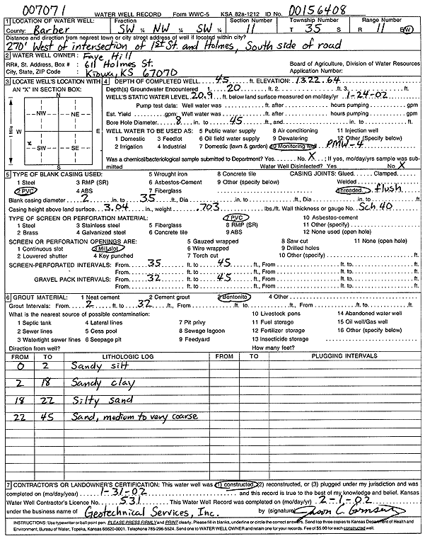
Specific Water Well Detail |
|
|
| Location Info | |||
| Owner: Hill, Faye | Status: Constructed | ||
| Location: T35S, R11W, Sec. 11, SW NW SW | County: Barber | ||
| Directions: from 1st and Holmes: 270' W, S side of rd | |||
| Latitude: 37.0110886 | Longitude: -98.4929733 | Datum NAD 27 | |
| Latitude: 37.0111159 | Longitude: -98.4933274 | Datum NAD 83 | |
| Longitude and latitude calculated by Survey from township-range-section-quarter calls. Only good to within the quarter call accuracy. | |||
| View well on interactive map | |||
| General Info | ||
| Well Depth: 45 ft. | Elevation: 1322.64 ft. | |
| Static Water Level: 20.9 ft. | Est. Yield: gpm. | |
| Comp. Date: 31-Jan-2002 | Well Use: Monitoring well/observation/piezometer | |
| DWR Applic. #: 007071, 00156408 | Other ID: PMW 4 | |
| Driller Info | ||
| Driller: Geotechnical Services, Inc. | License #: 531 | |
| Scanned Form | View scan |
|
Chemical Sample Submitted?:
Water Well disinfected?: | ||
| Casing Info | ||
| Casing Type:
Casing Joints: |
Diam: in. to ft | |
| Casing height above land surface: in
Casing Weight: lbs/ft Wall thickness or gauge no.: | ||
| Screen and Perforation Info | ||
| Screen Type: | Screen Openings: | |
| Screen-perforated intervals | From: ft to ft | |
| Gravel pack intervals | From: ft to ft | |
| Grout Info | ||
| Grout used: | From: to ft | |
| Source of Possible Contamination | ||
| Source: | ||
| Direction from well: | Distance: ft | |
| Lithologic Log
(Log data entered by KGS.) | ||
| From: 0 ft. to 2 ft. | sandy silt | |
| From: 2 ft. to 18 ft. | sandy clay | |
| From: 18 ft. to 22 ft. | silty sand | |
| From: 22 ft. to 45 ft. | medium to very coarse sand | |